Showing posts sorted by relevance for query Susan Wilkins. Sort by date Show all posts

Friday, August 24, 2012

Where is Novelty Hill?

This may get people scratching their heads.  I went to the library and read through the historical books on Duvall and the Snoqualmie Valley.  It appears that when Novelty lost most of its residents, people forgot where Novelty Hill was located. - Susan Wilkins

WHERE IS NOVELTY HILL?
By Susan Wilkins
Redmond, WA. 

In east Redmond, take Avondale Road north about a mile then merge right and follow Novelty Hill Road up to the top of the hill.  You’ll be in the Redmond Ridge/Trilogy area.  What hill are you on?  Most residents of Redmond Ridge will tell you that they live on Novelty Hill.  Google Maps says that Redmond Ridge is on “Novelty Hill/Union Hill”.  Longtime residents will tell you that you’re on Union Hill.  So which is it?  The correct answer is that Redmond Ridge is on Union Hill.  The confusion over the location started more than 20 years ago when planners and developers started referring to the Redmond Ridge area as Novelty Hill.  After all, they followed Novelty Hill Road to the top of the hill, so it made sense that they were on Novelty Hill.  The area was mostly forest and swampland so there was nobody around to ask. 
Where is Novelty Hill?  It’s up the hill from the town of Novelty – way over on the east side of the Snoqualmie Valley.  From the top of the hill at Redmond Ridge keep heading east, down the winding road.  At the stoplight at the bottom of the hill, turn left onto West Snoqualmie Valley Road, then right at NE 124th Street.  The bridge across the Snoqualmie River is called the Novelty Hill Bridge. What used to be the town of Novelty is on the other side of the roundabout.  Most maps still show Novelty as a dot located on SR203, a few miles south of the town of Duvall.  Novelty was once a little logging town with a long bunkhouse for loggers and a little store and post office.   The few old houses uphill to the east of the roundabout are all that remain of the town of Novelty. It still has its own zip code - 98019.  The real Novelty Hill is up the hill from the town.  If you have time, drive up the road to take a look.  There are a few houses here and there, and the Novelty Hill Cemetery is near the top, but all the narrow roads eventually dead-end.

If you’re not convinced, look at the accompanying maps. (USGS Carnation, WA 1993 -7.5 Minute series and USGS Seattle, WA 1992 - 30x60 Minute series)

Friday, January 4, 2008

OPINION: 520 widening: "No place for water to go!" - Susan Wilkins


Photo is taken of Bear Creek behind Safeway during the December '07 storm; not a good day to sit on the park bench!

OPINION about how the proposed state 520 widening project will impact our safety & welfare.

"It appears that the Washington Department of Transportation (WSDOT) never updated their flood maps and calculations to reflect the build-out of Redmond Town Center! The maps do show the Redmond Town Center (RTC) buildings and Bear Creek Parkway, but the flood maps are not updated to reflect that most of the 100-year floodplain that used to cover the RTC site is now filled in.
Bear Creek is now confined to the small channel area between the Bear Creek Parkway and 520 and of course it floods during a major storm event -- there is almost no place left for the water to go. And the WDOT wants to reduce this channel by another 30 feet! (Oddly, their document shows the new flyover bridge in a 100-year floodplain that doesn't appear in the 1998 map. Did anyone even look at this document before signing off on it?!)

It seems to me that the WDOT is using hopelessly outdated maps and data to justify their claim that the 520 widening will have no adverse effects on the stream, flooding and salmon habitat. "

Susan Wilkins, Redmond citizen geologist

How do you feel? Any thoughts?


-->

Monday, February 25, 2013

Letter: Improvements needed for LWSD busing

Susan Wilkins said...
The Lake Washington School District will spend $7,500,000 this year busing 8,500 K-12 students and 500 special-needs students to school. This is an astounding amount of money to transport relatively few students. Many people assume that providing additional bus transportation to Redmond Middle School will cost taxpayers even more money. This would be true if the school district were already providing highly efficient bus service, but an unofficial audit of the LWSD Transportation Department in 2011 found significant inefficiencies in the department. Although the school district had 85 full-size buses, only 65 were regularly scheduled with the rest being reserved for break-downs, replacements and field trips. And although the schools had staggered start times (high schools - 7:30 AM, junior highs - 8:00 AM, elementary - 8:30 & 9:00 AM) only 7 of the full size buses were efficiently scheduled to provide service to 4 schools each day. Most buses were scheduled for 2 regular routes per day. Buses were frequently assigned to schools on opposite sides of the district so that a lot of time was spent traveling across the district without passengers. Sometimes buses sat idle for 20 minutes between routes. Currently, bus routes are so poorly planned that students have to be at their assigned bus stops an hour before school starts and then ride bizarrely long routes on their way to school. Many parents give up on bus transportation and simply drive their children to school. (Note: these students live too far to walk.) Far too often, buses end up being only partially full. If the district planned the schedule for each bus more efficiently, with each bus carrying a full load of students and servicing 4 schools per day, then capacity would be increased without adding more busses or drivers. More importantly, with more students riding buses, the school district would receive significantly more than the $4,000,000 that it receives from the state in transportation reimbursement funds annually.

The LWSD Transportation Department has a bloated bureaucracy with one director and two supervisors earning a combined $240,000 per year. They have an additional 6 support staff who earn another $300,000. With more than $500,000 spent on transportation routing staff, it’s hard to believe how poorly planned so many of the bus routes are. Does anyone in the school district have any formal education in transportation planning? I have asked about this multiple times but the school district will simply say that their supervisors “have years of experience and are highly qualified.” According to Glenn Gorton, program supervisor for student transportation at the OSPI, “The state of Washington does not have any specific qualifications for Transportation Directors” ... “The hiring practices and qualifications for the individual school districts are handled on the local level and the local districts have the latitude to hire as they feel meets their needs.”   
 
Bus routing and trip planning software is available, but it requires a technology background and specialized training in order to get maximum efficiency. Providing training for the existing staff or hiring a seasoned computer-based transportation planner would save the school district thousands, if not millions of dollars, and many more students would be bused to school each day. 

There is a bright spot for possible transportation improvements on Education Hill. Students can ride Metro buses to school and LWSD will pay for bus passes for eligible students. Metro Bus #221 serves the Education Hill area but the bus route is not well synchronized with school start and end times. (How often do we see the bus traveling up and down 166th Avenue NE nearly empty?) Metro annually takes input and requests for route/schedule changes. I have asked the City of Redmond to work on morning and afternoon route changes that will coincide with school start and end times with the primary focus on helping students utilize Metro buses as an alternate transportation choice for getting to and from RMS and RHS. (This change would not take effect this school year.)

 
By Susan Wilkins
Education Hill and PTSA member

Sunday, October 21, 2012

OPINION: Avodale Crest Development on 104th Approved by City - A Neighborhood Traffic Hazard


The sight distance downhill is only 209 feet - far too little for drivers heading downhill to have time to stop.  That's why they had the no left turn provision in the first place.  It was the City of Redmond, not the developer, that pushed for the left turns into and out of the development.
UPDATED:   Avondale Crest Development was approved by the City on October 5 and is currently under appeal by Susan Wilkins. 

DEVELOPMENT IS A SERIOUS DANGER TO DRIVERS ON EDUCATION HILL

No access from Avondale Road

By Susan Wilkins
Education Hill, Redmond

OPINION:  When the Avondale Crest housing development was first proposed in 2005, the City of Redmond told the developer that access to the site had to be along NE 104th Street even though the 2.85-acre property also bordered Avondale Road. (RCDG 20D.210.20-080*) The slope of the hillside created blind spots for drivers along NE 104
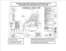
th Street so the original plan prohibited traffic coming down the hill from stopping and turning left into the new development. It also allowed only right turns for cars leaving the development – no left turns out of the development were allowed. (See the attached site map.) Even with the turning restrictions, more than 25 residents wrote to the city expressing concern and even alarm at the proposed site entrance because it was in a blind spot on the hill.

(Note: When a housing development is created from a larger lot or group of lots, there are two parts: the PLAT and the PRD (Planned Residential Development). The PLAT subdivides the land into smaller residential lots with the necessary street(s) and lot boundary lines. The PRD defines the requirements within the new neighborhood including house sizes, sewer lines, street lights, tree retention, open space requirements, etc. Plats and PRDs are usually designed and developed simultaneously and depend on each other - as was the case with Avondale Crest.)

When the Avondale Crest PLAT was issued on October 17, 2006, it required the installation of a fixed radar system on eastbound NE 104th Street and it also required a Stopping Sight Distance of 450 feet along NE 104th Street meaning that cars traveling down the hill should be able to see the entrance to Avondale Crest from 450 feet uphill. The restriction on left turns into and out of the development had disappeared.

I appealed the Plat and a hearing was held on December 11, 2006. I presented photos showing that it was impossible to see cars turning into the Avondale Crest development from 400 feet uphill because the road bends while dropping vertically. I argued that the lack of visibility of cars stopped down-slope on NE 104th Street would create a dangerous rear-end collision hazard. The traffic engineer and the planner for the City argued that because the fixed radar system would be installed to slow cars down to 25 mph, the 450-foot sight distance had been mitigated. The Hearing examiner sided with the City and approved the PRD and denied my PLAT appeal. I appealed to the City Council asking that the restriction on the NO LEFT TURN INTO AND OUT OF THE DEVELOPMENT be reinstated. Redmond City Council declined to add that requirement although they left open the possibility of requiring it later.

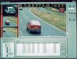
The fixed radar system was installed in early 2012 and data recorded by the system shows that fewer than 25% of cars are traveling along at the posted speed limit of 25 mph and more than 5% travel at least 10 miles over the speed limit. The data also shows that the number of vehicles exceeding the speed limit has steadily increased indicating that almost all drivers have started to ignore the fixed radar system altogether. I have often driven behind cars that the system recorded at 40+ mph - which is too fast to stop for turning traffic at Avondale Crest.

The Avondale Crest Plat that was approved in 2007 finally expired this past spring (after the City had granted multiple extensions.) Prime Pacific Bank that acquired the property when the developer went bankrupt decided that they would act as a developer and reapplied for plat approval. Instead of re-evaluating the project with the new data from the fixed radar system – and requiring that the developer add turning restrictions on NE 104th Street, the City instead approved the plat. The previous 450-foot stopping sight distance from the Redmond Municipal Code was no longer used and instead the planning staff used a new sight distance calculation from the new Redmond Zoning Code that seems to have far shorter sight distances and stopping requirements.

We now have a fixed radar system that actually tells us that cars are going too fast down NE 104th Street to stop for turning traffic at the proposed Avondale Crest intersection. It is obvious in 2006 when the project was originally approved that the entrance to the development was difficult to see and extremely dangerous. The proposed intersection is currently marked with orange tape and chalk. Can you see the entrance when you drive down the hill? Will you be able to stop for turning cars or crossing pedestrians? Are you afraid that you’ll be in an accident at this intersection? I am.

What should be done? The Redmond City Council should vote to amend the Avondale Crest PRD – an amendment that they specifically agreed to consider in the future when they approved the PRD. They should do it now.

-------

*During the past decade, the City of Redmond has allowed 3 other corner developments (PCC Market, Fairwinds Retirement Center and Aegis Living) to have direct access onto Avondale Road so it’s not clear why Avondale Crest was not allowed to have an exit and entrance onto Avondale, especially considering the acute danger presented by the sight distance limitations on the steep hill.

Thursday, March 21, 2013

LETTER: The planning steps LWSD needs to consider

Susan Wilkins said...
My suggestion that school construction on the west side of the district should have instead occurred on the east side re-ignited the debate about east versus west in the district. I didn't mean to imply that the east side is more deserving of construction. I believe we should carefully focus our construction money where it's needed most and in proportion to what is actually needed.

What I am dismayed at is that so many schools in the district have been torn down and completely rebuilt - and most of those schools happened to be on the west side of the district and were still in fairly good condition. When we voted we were told that these schools would be "modernized" and I thought that meant updated or remodeled. To me, modernization means replacement of aging plumbing, electrical, lighting, doors, windows, carpeting/flooring, etc. But the school district figured out that they could justify tearing down and replacing the buildings if they added enough new features and space requirements that it would cost as much to remodel as it would to rebuild. What started out as a sensible district-wide remodeling schedule has morphed into a total teardown mentality with plans to replace every school in the district. The school district routinely spends an outrageous $35,000,000 tearing down and rebuilding elementary schools and insists on calling it modernization! Bell, Keller, Juanita and Thoreau Elementaries each have about 300 students and are only partially full. These schools are all brand new and were rebuilt even as schools elsewhere in the district were flooded with students who ended up in villages of portables.

At the same time, it is very clear that Juanita High School has a multitude of maintenance issues that have been neglected for years. Lighting, heating, ventilation and electrical systems are all in need of updating and basic maintenance. Has Juanita High School not had any maintenance because the school district just assumes it will tear the school down? Can Juanita High School be updated without tearing the building down or is it so inherently flawed that it is beyond repair?

Long-term, central planning (or lack of it) seems to be at the root of the school district's problems. The district has built 19 brand new school buildings in the past 15 years, but they have never figured out how to match student populations with space availability. (Should I remind everyone that Wilder was left half empty while Rosa Parks overflowed with students!) Transportation planning and facilities planning are both managed by the same department and bussing is a mess. Short (2-3 mile) bus rides can take 45 minutes and bus stops are often far from students' homes. (Although the district manages to provide a bus that takes students from Redmond Ridge across to ICS in Kirkland in just 25 minutes.) The school district has the names, addresses and grade levels of all the students in the school district and they could use planning software to balance student populations AND to transport students efficiently and quickly to their schools. (The district must coordinate transportation planning and facilities management to make it work.) The school district tells us that moving school boundaries is "tricky". Well, it is tricky, but with computers and well-designed software (try ESRI's ArcGIS series), it is very possible. Big companies like Microsoft have facilities planners to manage their many employees in many buildings. FedEx, UPS and the Post Office have delivery route planners. Maybe LWSD should call up these companies and ask for some planning advice.

By Susan Wilkins, Education Hill, Redmond

Monday, January 23, 2012

UPDATED: Part One: Bus Transportation and Overcrowding Problems at Rural Alcott Elementary


CLICK TO ENLARGE
Bus Transportation and Overcrowding Problems at Rural Alcott Elementary

By Susan Wilkins

LETTER:  Alcott Elementary and Rockwell Elementary are two identical schools built from the same architectural plans in the mid-1980s. Rockwell is centrally located in the middle of an urban neighborhood on Education Hill in Redmond. Alcott Elementary is a rural school along Redmond-Fall City Road that was built for rural students who live in the sparsely populated east side of the school district. When we compare the number of students who are transported to each school by bus and the distance that students must travel, we see that locating schools inside Urban Growth Boundaries where students live is more convenient for students and saves school districts money on transportation costs.

Alcott Elementary has an unusual student population.  Read More >>

Saturday, March 16, 2013

LETTER: The Office of Superintendent of Instruction appears to have erred on transportation efficiency ratings

Susan Wilkins said...
Being familiar with school bus transportation here in Redmond and having recently written about how bus transportation could be improved, it seemed odd that the OSPI would rate the Lake Washington Transportation Department at 100% efficient.

I visited the OSPI website and reviewed the supporting documents and reports that were posted with the school district transportation department efficiency ratings. The OSPI’s Efficiency Detail Report for the Lake Washington School District listed LWSD as having 12,924 basic riders and 1,210 special ed riders. (Total bus riders: 14,134) It also noted that the district had spent $7,532,315 on transportation in the 2011-2012 school year and determined that the school district’s relative efficiency rating was 100%. The Lake Washington School District has only 25,400 students. The idea that more than 14,000 students ride buses to school each day is hard to believe.  Read More >>

Friday, November 9, 2007

05/2007 - Active landslide on Perrigo Heights

2007 was the year I started my blog


"Landslides Threaten Big Trees, Sewer Alignment at Perrigo Heights" - by Susan Wilkins, Redmond, WA.

Preface: The initial geotechnical engineering report on Perrigo Heights was done in 1997. It's possible that the slope along the access road where the slides are now occurring was much more stable back then. At that time, the report stated that the whole property was stable. That was 10 years ago. Since then, time, gravity and severe weather have destabilized the north side of the property and it is sliding and unstable. This article and photograph are simply pointing this out.

A series of landslides along the access road on the south side of Perrigo Creek has toppled a number of trees and has left a majestic big-leaf maple precariously leaning with its roots exposed on the steep hillside. The tree sits on what is called a bench slide, a whole piece of the hill that is moving down-slope as a unit. It’s an historic slide that has been occurring slowly for years. It probably started years ago when the City of Redmond cut into the hillside when it built the access road that runs along the south side of the creek. The effects of gravity and the heavy rains this past year has caused the soil under the roots to break up and collapse. The landslide begins at the top of the slope where caving with the classic “scooped out” appearance can be seen on the relatively horizontal section of the hill where the proposed sewer line for the planned Camwest Perrigo Heights Development will run. In some places, the sewer line boundary will be within 15 feet of the top of the collapse.

Sunday, November 11, 2007

UPDATED: Almost EVERYONE WINS! - Redevelopment of the Keller Farm, 9/3/07

UPDATED on 4/18/13.   It's my understanding the wetland bank program has been delayed for 5 years.  I don't know the details, but you could contact the city council ombudsman at council@redmond.gov for an explanation. 

OPINION:  My friend and neighbor, Richard Morris, wrote a "guest" blog a few months ago about new developments at historic Keller Farm near Avondale and Union Hill road. Recently, the planning commission has been holding public meetings on the project. The commission graciously left their meeting open for "comment". If you have something to say for the record, you may still comment (as of 8/5/07) to the planningcommission@redmond.gov

If ever there was a WIN-WIN land-use & re-zone project in Redmond THIS is it!
Below is an assessment of community needs that will be satisfied by the Aegis Living - Keller Farm development.
  1. Mr. Keller, owner of historic Keller Dairy Farm and now pumpkin farm has agreed to sell his land to a developer, but the low density residential zoning and Critical Area characteristics impeded progress and land values.
  2. The City classified much of Keller's land as protected, "critical areas" -- 1) recharge zone for maintaining our well water supply, 2) and hazardous flood zone, 3) riparian and fish & wildlife Protection Area; and wetland making re-zoning and development difficult.
  3. Aegis Living retirement company sought a premium location to attract and service their retirement clientele and obtain a location close to their corporate headquarters.
  4. The long-time landowners with grandfathered 25 foot buffers on Evans Creek want to increase the value of their land so that SE Redmond can be redeveloped. Evans Creek is a salmon bearing, straight channel with little or no riparian habitat or buffers.
  5. Perrigo Creek is taking on higher concentrations of stormwater run-off from new developments (Perrigo Heights, 180 Ave, and SR 520) presenting negative impacts to priority Bear Creek habitat.
  6. Environmentalists (Muckelshoot Indian Tribe, WaterTenders, community activists) want to protect priority open space, habitat, and species.
  7. Redmond Historical Society and residents want to preserve our heritage and our view corridors.
  8. Congested traffic needs to be mitigated on Avondale Road during redevelopment of the corridor.
  9. 5000 senior citizens 65 years and older live within a 3 mile radius of Keller Farm and will need retirement accommodations and care.
  10. Affordable housing is scarce for residents and workers in Redmond.
  11. Wetland mitigation banks are needed in Redmond to facilitate growth.
How the above needs will be satisfied (in sequence):
  1. The residential and agricultural zoning of Keller Farm will be amended to "Bear Creek District" allowing Mr. Keller to sell his 126 acre farm for a good return to Aegis Health Care (8.8 acres) and a "wetland bank" entrepreneur ((117 acres).
  2. A "wetland bank" is created in partnership with the the city and Aegis. The bank allows the city to protect their valuable recharge wellhead protection zone, protected riparian habitat and species, priority flood zone & wetlands. Susan Wilkins stated our 1998 FEMA Flood Map was dated. Kim Richardson had concerns about pesticides.
  3. Aegis Living, website here, will build a state-of-art retirement complex next to their corporate headquarters. Assisted living with focus on memory care will be provided. Alzheimer's is expected to grow by 10-fold by 2050. 1 in 5 citizens will be over 65 by 2030, according to Brain Poge of Aegis.
  4. An easement is created in the wetland bank to allow for re-routing & meandering of Evans Creek away from SE Redmond businesses. Riparian habitat will be restored and creekside resident land value will increase stimulating redevelopment of SE Redmond.
  5. Perrigo Creek currently runs underground 1000 feet in a pipe along Avondale. It will be "daylighted" to a swale (grassed ditch), the stream water -- oxygenated, filtered and re-routed away from Avondale wastewater before draining into Bear Creek - improving stormwater treatment and Bear Creek water quality.
  6. The wetland bank will be used mostly for wetlands paved over by roads, high schools, and trails and will not replace on-site mitigation. Victor Woodlasnd, wetland banker partner, has a 10 year commitment to restore banked units. Within 20-years the wetland bank will be endowed in perpetuity to the Cascade Land Conservancy. The wetland bank will be restored with trees and shrubs native to wetlands. Man-made ditches will be removed. Trails should be pervious (Dick Schaetzel) and secondary to the flow of the creeks (Ed Schein). Bear Creek is a channel. Off channel rearing of fish is superior and more likely after restoration. (Bill Shields).
  7. Aegis Living residents do most of their driving during off-peak hours so they are a good business for busy Avondale Road.
  8. 10% of the units will be set aside for affordable housing for workers and possibly residents.
What appears to be "unfinished business" or issues of concern are, as follows:
  • "Avondale Green Homeowners Association" is not opposed but they want a 2nd exit onto Avondale and a U-turn for safety.
  • a small triangular neighborhood next to Aegis is unhappy with the Aegis Road going next to their neighborhood.
  • Susan Wilkins duly noted concerns about our dated 1998 FEMA Flood map. Staffers agreed that mapping work needed to be done. Susan presented photos of the proposed Aegis tennis courts in the 1998 flood plain.
  • Jill Richardson had duly noted concerns about pesticides.
The wetland bank is highly regulated, but the City of Redmond has final say via permitting and the debit side of banking. The Dept. of Ecology and Army Corps of Engineers are next in line. The EPA has some jurisdiction, as well. City Environmental planner, Cathy Beam, and Planner Jeff Churchill worked hard on this project and did a great job.

Project review and rezone are almost finalized. The Department of Ecology will consider a Public Hearing - by request only.

** The photograph above is of cow pasture along Bear Creek. It may be Keller Farm. This photo is on the front cover of Redmond Historical Society's new soft-cover titled "Redmond Reflections - from settlers to software", written by Naomi Hardy. To order write redmondhistory@hotmail.com.
Redmond City Technical Report of the Aegis project is HERE

FACTOIDS - a 225 acre wetland in Duval was the first wetland banking site in WA. Washington State Dept. of Transportation (WSDOT) owns 5 wetland banks. Two banks are in Skagit county and one in Eastern Washington. >> wetland banks are booming across the country but are limited in Washington State by stronger regulations.
Planning commission's final recommendations to Council of 9/28/07: http://www.redmond.gov/insidecityhall/citycouncil/CurrentAgenda.asp

Tuesday, February 12, 2013

Letter about traffic at Redmond Middle School - Updated with new comments

LETTER ABOUT TRAFFIC AT REDMOND MIDDLE SCHOOL

By Susan Wilkins
The Redmond Municipal Code states:
10.52.145 Fire lanes.
(a) Fire Lane Parking Prohibited.
(1) No person shall stop, stand or park a vehicle or maintain any obstruction within any fire lane.
The drop-off lanes in the two parking lots in front of Redmond Middle School are designated FIRE LANES so it is illegal for parents to pull into the lanes and drop off their students or to wait for them at the end of school.
The pick-up/drop-off lanes in the RMS parking lots were improperly designed when the school was rebuilt in 2002 but the Redmond Police and Fire Departments never made an issue of the defect or required the school district to fix it. I wrote a letter to the City of Redmond Police Department last fall 2012 asking them to address the Fire Lane violations at the front of Redmond Middle School. Greg Palmer who does Traffic Calming for the City phoned me to discuss the issue. Basically he said that the City wasn’t going to do anything about it because it had been that way for so long. He also said – and this is significant - that nobody had complained about it. I noted that I had just filed a complaint and that was why he was calling me! Apparently, one complaint isn’t enough. So everybody, call or email and COMPLAIN to the City of Redmond. Tell them to fix the traffic mess at Redmond Middle School !!!
SHORT TERM SOLUTION: The school already has a driveway that leads from the south parking lot and wraps around the back of the building where the busses drop off students. Parents could drive around the back and drop off students without obstructing the fire lanes. The school district should also hire certified traffic flaggers to direct traffic in and out of the parking lot driveways and onto the streets (like they do at Rosa Parks Elementary.) 
LONG TERM SOLUTION: The City of Redmond should require the school district to redesign their parking lot and entrance/exit configuration so that parents are not using the fire lanes for pick-up and drop off. The redesign should also accommodate the 400+ cars that pass through the school’s lot every morning so that back-ups don’t cause total obstruction and traffic chaos on 166th Avenue NE and NE 104th Street. Redmond Middle School is located on a 24-acre parcel with the school building squeezed onto the northeast corner of the lot. There is plenty of extra space on the property to relocate entrances/exits, driveways, drop-off zones and parking lots.
Two years ago I posted a video of the typical driving antics that occur at RMS/RJH every morning. You can view it at http://www.youtube.com/watch?v=J4a4aG05O44. We wouldn’t tolerate traffic like this from a WalMart, would we?
A more important question to ask is why are so many students being driven to school every morning? Where are all the Lake Washington School District buses? If the school district provided quality, efficient bus service to the outlying neighborhoods along NE 116thStreet to the north, along NE 104th Street to the east and along 166thAvenue NE down the hill to the south, car traffic through the parking lots would be significantly reduced. It used to be that students had to live more than 1 radius-mile from the school to be eligible for school bus transportation, but in September 2011, the Legislature changed the bussing formula and any student who has to walk more than a mile along existing streets became eligible for bus transportation. The LWSD Transportation website still says that students must live outside a 1-mile radius in order to be eligible for bus transportation. The school district needs to wake up and read the RCW (28A.160.160) and start providing bus service to students who are eligible under the new 1-mile walk route guidelines and not under the old 1-mile radius rule!!!
Even if the school district adds more bus transportation to Redmond Middle School and reduces the traffic backups on 166thAvenue and 104th Street, the practice of using the fire lanes as drop-off and pick-up lanes is illegal and needs to stop. Someday there is going to be an emergency at RMS or at a nearby residence and the fire trucks and ambulances will not be able to get through in time.
Please take a moment and contact the City of Redmond and tell them to fix the Redmond Middle School traffic problems. Contacts are listed below.
Mayor John Marchione: mayor@redmond.gov
Redmond City Council Members: council@redmond.gov
Redmond Traffic: https://www.redmond.gov/PublicSafety/Police/traffic_concern_form/
 
By Susan Wilkins
 

Sunday, October 25, 2015

UPDATED: Thoughts from an engaged citizen about LWSD's facility plan and land acquisition strategy

COMMENTARY (by Susan Wilkins):  I agree that building a middle school at Redmond Ridge is a good idea since many students live nearby and they could walk to school.  The issue is that the district already has Evergreen Middle School (EMS) that those students can attend.  If the district's plan were to build the new middle school at Redmond Ridge and get rid of EMS, that would make sense, but the district's proposal is to tear down and rebuild EMS with space for 1000 students and that means that students who live in downtown Redmond and on the east side of Education Hill will be bussed out to EMS.  Evergreen is 3 miles outside the city limits on Union Hill Road. I live near Hartman Park and my entire neighborhood would likely be zoned for EMS.  The trade-off is that Redmond Ridge will get a "walkable" school and my neighborhood will be bussed to far-away EMS.  I don't think this is a reasonable solution.  Read More>>

Tuesday, September 7, 2010

LETTER: Red Light & Speed Cameras Planned for Redmond, By Susan Wilkins

RED LIGHT & SPEED CAMERAS PLANNED FOR REDMOND

City Council will decide whether to authorize cameras at 7:00 PM meeting on Tuesday, September 7

The Redmond City Council’s Public Safety Committee has been discussing the use of traffic cameras to, in their words: “modify dangerous behavior, reduce preventable collisions at signalized intersections and prevent car-pedestrian accidents in school zones.” As a parent of school age children who has been trying to identify and improve safety and reduce school-generated traffic on Education Hill for the past year, I am offended and bewildered by this lame attempt to provide improved safety through the use of traffic cameras. They plan to pass an ordinance at Tuesday evening’s City Council Meeting that authorizes the use of Traffic Speed Cameras in school zones and the use of Red Light Cameras at intersections. 

During December 2009, a company called American Traffic Solutions (ATS) conducted traffic surveys on a number of intersections and school zones in Redmond. They suggested that a speed zone camera be installed at Redmond Junior High to catch drivers exceeding the 20 mph speed limit while driving up 166th Avenue NE as they approached RJH from the south. There are severe traffic safety problems at RJH, but speeding in the northbound lane on 166th is the least of them. In the initial pilot program, a traffic speed camera will not be installed at RJH, but it is planned for a year from now. This is not a solution for the RJH traffic mess – it will just generate traffic tickets.  Read More!

Monday, January 30, 2012

'LWSD's First Assignment for 2012' - Conduct a facilities inventory and audit of classroom space, with Superintendent oversight

Is this is a classroom?  Can it be a classroom?   (LWSD photo)
OPINION:  LWSD’S FIRST ASSIGNMENT FOR 2012 – Do a facilties inventory and find out how much classroom space the school district really has. 

By Susan Wilkins
Redmond, WA.

UPDATED:  How much space does the Lake Washington School District have at its 31 elementary, 12 junior high and 8 high schools? How many classrooms are there and how many students can each school hold? How many students can all of the district’s schools hold? These are important questions considering we were just asked to spend $65,000,000 to build additional space for high school students.  Superintendent oversight is required.

The answers to these questions about classroom space can be found on page 24 in the district’s “Six-Year Capital Facilities Plan 2011-2016.” (This document can be found at http://www.lwsd.org/SiteCollectionDocuments/For-The-Community/Construction/Capital-Facility-Plan.pdf ) On a single page, the district counts all the classrooms in all the schools and then multiplies by the number of students each classroom can hold and then figures out the total capacity of the district’s facilities.
The trouble with this accounting system is that it is too simple. It assumes that if a classroom is used for an activity other than regular classroom teaching, it should not be counted in the inventory. If a classroom is used for Music, Computers, Art, ELL, preschool or even storage, it is not included in the total number of classrooms in a school.

Let’s look at Rockwell Elementary... Read More >>

Sunday, January 23, 2011

LETTER: Overcrowding at elementary schools may not be real, By Susan Wilkins

OVERCROWDING AT ELEMENTARY SCHOOLS MAY NOT BE REAL

LETTER:  As a parent of four students currently enrolled in the Lake Washington School District, I have had many years of volunteering and attending events at their various schools. Over the past decade, my children have attended Mann, Rockwell, Einstein and Rush Elementary Schools, as well as Redmond Junior High and Redmond Senior High. I have had the opportunity to observe day-to-day activities first-hand while volunteering and attending events at the schools. I voted for bond measures, EP&O and technology levies and I-728, the initiative that was passed to reduce class sizes in 2000.

We are now being asked to pass a $66 million dollar levy on February 8 to add additional space at Redmond High School and Eastlake High School and to build a new Science and Technology High School out on SR202 on the lot next to Alcott Elementary. The district has claimed through its mailings and speeches that we are almost out of space for students, that more students are arriving every year, and that soon we will be double shifting or transporting students long distances by bus. While some schools, such as Rosa Parks Elementary at Redmond Ridge and Alcott Elementary east of Redmond are extremely overcrowded, most of the schools in the district are overcrowded because of the way the district defines school capacity and not because there are too many students.

Let’s look at how the district determines whether a school is overcrowded. At each school, the facilities department counts all of the homeroom classrooms in the school and portables, and then multiplies that total by a set number of students per classroom. For elementary schools, the set number of students per classroom is 23. So for example, at Horace Mann Elementary, they have 17 classrooms and 17 x 23 = 391*. Enrollment at Horace Mann for the 2010-2011 school year is 483, so by the district’s definition, the school is very overcrowded.

Monday, September 24, 2012

OPINION: MORE BUSSES ARE NEEDED FOR REDMOND HIGH SCHOOL


"New Walk Area Boundary" is in blue. (Click to enlarge)

MORE BUSSES ARE NEEDED AT REDMOND HIGH SCHOOL FOR STUDENTS WHO WALK MORE THAN ONE MILE TO SCHOOL 

By Susan Wilkins
Redmond, WA. 

When Redmond High School opened this September with 2000 students and staff, only 8 busses were provided for the entire school – enough seats for about 400 students to ride to and from school. 

In September, 500 additional ninth graders arrived at Redmond High as part of the 9-12 grade conversion. The brand new 14-classroom south wing and auxiliary gym were also opened for the first time.  Redmond High School is now one of the largest high schools in Washington State with almost 2000 students and 160 teachers and staff.  Before final construction plans were approved by the Redmond City Council, the project went through a series of reviews and hearings where such issues as severe traffic back-ups, noise, overcrowding in the halls and lunchroom, and even inadequate locker counts were considered. 

A major issue that was raised with the city Hearing Examiner in May 2011 and at the final approval hearing held by Redmond City Council in July 2011 was the change in state law (28A.160.160 RCW) that would allow school districts to be reimbursed by the state for transporting students who had to walk more than a mile to school. Prior to the change in the law, funding for school bus transportation had been limited to students who lived outside a 1-mile radius from the school meaning that many students who had long walks to school because of steep slopes, winding roads and other geographic features were not provided bus service and instead ended up driving or being driven to school.   The State Legislature amended the 1-mile radius requirement and instead created the definition of a “1-mile walk route” meaning that any student who had to walk more than 1 mile to school would be eligible for state transportation funding.   

Under the 1-mile radius rule, students living along Avondale Road, 166th Avenue NE and on the north and south sides of the NE 116th Street corridor were not eligible for school bus transportation even though most would have walked 2 to 3 miles to get to school by following the existing roadways.  With the creation of the “1-mile walk area” hundreds of RHS students became eligible for bus transportation funding from the state.  The catch is that although the state will provide funding, the local school districts are not required to provide bus transportation except to students with special needs. 

READ MORE >> 


Sunday, August 29, 2010

LETTER: Inadequate bus transportation brings 1500+ vehicles to Education Hill each morning

SCHOOL TRAFFIC ON EDUCATION HILL - COMPARABLE TO TRAFFIC AT COSTCO
By Susan Wilkins, LWSD parent and volunteer

It’s great to live on Education Hill during the summer – school is out and kids get to sleep in, the baseball fields are busy, the view of the Cascades is awesome, and morning traffic on Education Hill is nearly non-existent. But the day that school starts, this year on September 1st, is the day that our snarling traffic will return. Obviously, our schools are the source of our traffic, with so many kids being dropped off by their parents and the high school students driving themselves to school. Also, don’t forget that the schools have almost 200 full-time employees. Understanding how many cars are coming and going and which schools are generating traffic can help us figure out how to fix it.
TRAFFIC BY THE NUMBERS (a little boring, but count along….)
Redmond High School has 1440 students and a staff of 120 who start arriving from all directions in their cars shortly before 7:00AM. Only 230 students ride the bus to school, the rest arrive in cars, either by driving and parking or being dropped off by a parent. Redmond High School attracts nearly 900 cars to the neighborhood between 7:00 and 7:30 AM each weekday morning. As a comparison, this exceeds peak hourly traffic at Costco which attracts about 700 cars per hour.*

Redmond Junior High has 850 students and about 70 staff members. During traffic counts in May, nearly 400 cars dropped off students between 7:25 and 7:50 AM. More than HALF the students at RJH arrived at school in private vehicles. RJH also had 5 buses that dropped off 215 students.

Horace Mann Elementary had 470 students and a staff of about 40. On a typical morning 180 cars dropped off students in the parking lot and another 60 dropped off students at various outer streets, a total of 240 vehicles. Mann had one bus that dropped off 12 Redmond Elementary transfer students.

With 3000 students and staff arriving at 3 schools in 1500+ vehicles, we have a huge traffic mess that's not going to be fixed by telling people to “walk to school”.  So, will the school district and the City of Redmond stop telling us that this will solve our traffic problem?  Read More.........

Tuesday, August 30, 2016

Restoring Tosh Creek improves fish habitat and mitigates flooding in the Overlake neighborhood

City Planner Roger Dane (l) and Project Manager Steve Hitch book-end Tosh Creek

Susan, Bob, and Steve
Credit John Reinke
A few weeks ago Steve Hitch and Roger Dane of the City went out of their way to give Water Tenders’ Susan Wilkins, John Reinke, and myself a short tour of the Tosh Creek Restoration Project.   Do you see the creek running between Roger and Steve?  

Salmon fry and lamprey were found right at this spot in May.  Can you believe it? You've got to watch the City’s fascinating underwater video!    (removed.)


Tosh Creek is an important tributary to the Sammamish River. Its headwaters are actually in the Overlake neighborhood up the hill from West Lake Sammamish Parkway.  In 2013, the culvert running under the parkway was improved and the stream was re-aligned away from the road to be more "fish friendly," and to reduce sediment build-up near the culvert.  Willows and other native plants were planted to shade the creek and keep it cool. The $1.9M project was managed by Roger Dane and Mike Haley and funded primarily from city stormwater utility funds.

The Sammamish River's federally protected Chinook salmon and endangered Kokanee salmon need the cool water Tosh Creek provides to thrive and reproduce. Coho salmon and trout live in Tosh Creek. As small as Tosh Creek is, its flow is significant in the Fall when salmon are spawning and need cool water.  

But, the restoration of Tosh Creek does much more than improve fish habitat.  Serious erosion and flooding from stormwater run-off upstream is damaging the creek and threatening adjacent properties.  Thus, the city is installing an expensive stormwater detention system (vault) near 159th Avenue NE. and facilities in 4 other locations.  The cost for the vault is over $8M but the city was able to secure a  $5M grant and $1.6M low interest loan from the Washington State Department of Ecology. 

This is a bit more than a fish story!  At the end of our tour we saw a doe and two fawns wandering south from the creek. Hmmm.... I wonder what they were doing? 
 If you want to participate in the planning process of the vault and treatment facilities, Steve is hosting two September meetings.  For details, GO HERE. 
Bob Yoder

Thursday, October 5, 2017

The Planning Commission openly deliberates on key issues, the Comprehensive Plan

(l-r)  Stephanie Rodriquez, Vidyonana Rajpatkak, Chair Scott Beithan, Vice-Chair Roy Captain, Phil Miller, Sherri Nichols.
 Planning Director Karen Haluza and  two Senior Planners are sitting with backs turned.  
Every year the City offers citizens, developers, property owners and other entities an opportunity to amend (update) the Comprehensive Plan. This amending process is a Planning Commission duty of high significance and importance.

The Planning Commission has been meeting for months to take input and review five re-zoning proposals for consideration of being "calendared" or docketed for further review and approval by the Commission and Council.     

This LINK provides every topic currently under review by the Planning Commission.   It includes docketing proposals, memos, staff recommendations, public/developer comments, exhibits and project approvals. Below are a few topics under review:    

1)  The City is currently proposing to update to their Capital Facilities Element titled   "Future Vision for Redmond - Capital Facilities Element."  The proposal is already docketed and contains a lot of interesting information about the City's future plans. Find it HERE

2)  It's my understanding a proposed "Quadrant Homes" rezone from "Business Park" to "Mixed-Use Development" will be re-docketed.   Quadrant is considering constructing 165 town homes, 300 apartments, and 10,000 s.f. of retail/commercial space on 15.57 acres -- on the SW corner of NE 124th & Willows Road. Installing a stoplight on the corner is in the proposal.  


The N.Y,C. developer
3)  A controversial, long-winded proposal by an aggressive N.Y.C developer, Capital Partners is under consideration by the commission.  The developer wants to rezone 4.21 acres on the corner of Avondale and NE 104th from R-4 to R-30. Staff members (the "TC") are not recommending approval though a rezone to R-12 for senior housing is a possibility.  (It seems the commission usually goes along with many or most of the TC's recommendations.)  

4)   A while back, the owners of Redmond Town Center (RTC) proposed a modification of their "Open Space Designation" agreement with the city.  They have since withdrawn this proposal.  

Interesting background:  A 1997 agreement between the City and RTC conveyed a perpetual, non-inclusive easement to allow "among other things, the right to operate a farmers market"  Presently, the "Saturday Market" is located on this 2-acre easement.  Termination of the Open Space Designation requires a mutual agreement between the City and RTC.  

5)  Susan Wilkins, a Redmond citizen, asked the commission to docket an amendment to the zoning code to "adequately plan school facilities" so students residing inside the City of Redmond are not required to travel outside the Urban Growth Boundary in order to attend school. The Planning Commission voted against the proposal.  Ms. Wilkins put in a ton of work, without pay, to formulate this proposal.  Planning commissioners don't get paid either.  

The commissioners are citizen volunteers living in Redmond, appointed by the Mayor and approved by Council.  They don't make land-use decisions; they conduct Hearings and serve only as an advisory body to Council.  

B.Yoder
photos/by

Disclosure:  Trying to understand the Planning Commission's reviews of complex topics is very challenging.  Expect errors, omissions and mis-representations. 

Wednesday, June 8, 2011

Transportation, Traffic, and Parking studied by School Board -- STEM school project approved.

"Citizen Participation in the Planning Process -- a horrifying prospect for some administrators -- has proved to be the most effective way to avoid mistakes and unintended consequences."  Duany, Plater-Zyberk, and Speck, Suburban Nation, 2000.
JUNE 16, 2011  On Monday, June 8th the Lake Washington School Board made a unanimous decision to approve Hearing Examiner Jim O'Conner's  recommendation to build the STEM secondary school.  STEM is an acronym for Science, Technology, Engineering and Math and is sorely needed in the district (and around the country.)
Citizen participation in this STEM project was robust with 15 citizens speaking at the April 5th Hearing and others emailing Sup. Kimball and staff.  Mr. O'Conner conditioned his recommendation with the following  items brought to his attention by citizens at the Hearing:    READ MORE >>

Monday, February 27, 2012

OPINION: "Avondale Villas" development calmed by speed feedback safety sign.

Orange tape marks the width and entrance to Avondale Crest's (Villa) road from NE 104th, photo (2007). 
This car didn't slow down and is already out of sight.
Avondale Villas development pays $12,000 towards cost of radar speed feedback sign on 104th - for traffic calming.

OPINION:  Have you noticed the new “radar feedback sign” on the NE 104th Street hill, just above the 184th Ave. NE intersection? It’s hard to believe the speed limit is 25 mph on this highly traveled arteriole.. Most cars, some of them students, zoom down the curved hill at 40 mph.

Since the radar sign was installed most cars are slowing down before they get to 184th, but not all. (Many thanks to the 6,000 citizens petitioning to eliminate red-light cameras.)

According to a Public Works planner, “the $30,000+ radar sign” wasn't just installed for traffic calming for the 184th intersection. The city required the sign as a condition for the project's approval.  This controversial 9-lot residential development was called “Avondale Crest.” (re-named Avondale Villas.) City Council approved the plat (6-1, Allen) after an appeal was defeated 4-3. 

Two project defects delayed permitting and is holding up the sale of Avondale Crest (Villas): Read More >>