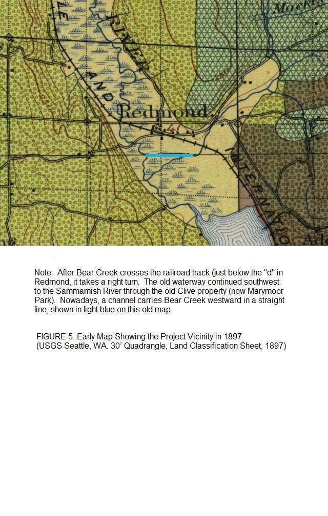
Showing posts sorted by relevance for query bear creek. Sort by date Show all posts

Thursday, June 6, 2013

Redmond City Council approves Phase One of Funding to rechannelize Bear Creek away from SR520

             Council awards $3,414,472 to KLB Construction to rehabilitate Bear Creek 
 
Background
 
The Bear Creek Rehabilitation project will rehabilitate the lower, channelized part of
Bear Creek starting at the Sammamish River and going upstream on Bear Creek to the
Bear Creek enhancement work previously completed. About 3,000 feet of Bear Creek
will be completely relocated from the mostly straight, channelized “stream” to a
meandering, reshaped and re-planted channel in the existing open space.
 
The project will establish stream buffers consistent with the City’s Critical Areas
Ordinance with allowance for the Washington State Department of Transportation
(WSDOT) “Stage 3” widening of the SR520 freeway adjacent to Bear Creek. The
existing asphalt path will be relocated and augmented with a soft-surface parallel path and
“side-routes” that will allow people to walk over to the stream and to view and interact
with (a much improved) Bear Creek.
 
The rehabilitated overbank areas will address flood conveyance issues and will provide
other habitat improvements.

History   Read More >>

Tuesday, April 29, 2008

OPINION: THE SR520 EXPANSION BETWEEN THE SAMMAMISH RIVER BRIDGE AND REDMOND WAY - From 4 lanes in 1992 to 8 lanes in 2008. But at what cost?

How many people remember what traffic was like on 520 in Redmond in 1992 when the freeway expansion and improvements were first approved? Back then, the eastbound lanes of 520 ended at the stoplight on Redmond Way and cars waited in line to cross onto Avondale Road or turn left or right onto Redmond Way. A trip from Overlake in Bellevue to UPS on Union Hill Road in the afternoon could take an hour or more. The addition of the flyover so that cars didn’t have to stop at the light on Redmond Way was such an improvement (although everyone was dismayed when it only had one lane in each direction.) In the past year, an additional flyover was built to allow traffic from westbound Redmond Way to flow directly onto 520 without stopping at the traffic lights on Redmond Way. This summer the Department of Transportation plans to start adding four additional lanes to 520 so that there will be four lanes in each direction. The new lanes are to be built on the north side of the freeway in the area now occupied by the Bear Creek floodway. click picture to enlarge


In 1992, the Redmond Town Center site was an empty field that had been a golf course and before that, a farm. The land was part of the Bear Creek 100-year flood plain so when a major storm occurred, storm water from Bear Creek could flood north towards the railroad tracks where the main parking garage, REI and Macy’s are now located. The whole area could flood to a depth of 2 to 3 feet for a day or two and then the floodwater would recede. When Redmond Town Center was constructed, most of the site was filled in with millions of cubic feet of trucked-in dirt and the elevation of the entire site was raised about 5 feet. Stores, offices, parking lots, roads and sidewalks have been built and the empty fields that once stored floodwater from Bear Creek now contribute to the run-off that flows into the creek. Even more of the flood plain was filled when the Bear Creek Parkway was built around the perimeter of the mall.

Upstream along Bear Creek and Evans Creek, new developments have dumped their overflow runoff into tributaries and storm channels that drain directly to the creeks. The creeks now overflow their banks when the valley gets more than 2 inches of rain in a day. The Keller Farm fields between Avondale and Union Hill Roads regularly flood with storm water from upstream. With the extra floodwater from upstream and the flood plain north of Bear Creek filled and built up, the floodwaters from Bear Creek fill the entire channel between the Bear Creek Parkway and SR520. During the December 3, 2007 storm, the floodwater was within 3 feet of the shoulder of the westbound lanes of 520!

There is way too much water flowing through a channel that has been narrowed by the Town Center development on the north side of the creek. And the Washington Department of Transportation (WSDOT)wants to reduce the channel and floodway on the south side of the creek even more by adding four more lanes to 520. The new lanes will extend 40 feet north of the westbound shoulder where floodwaters gush whenever we get a major storm. Untreated run-off from the new lanes will be washed directly into Bear Creek during major storm events. Salmon depend on this channel to get to their highly productive spawning beds upstream in Bear Creek, Evans Creek and Cottage Lake Creek. Narrowing the floodway with the new lanes could also cause severe flooding upstream especially near the Bear Creek Shopping Center and along Redmond Way.

The SR520 expansion plan was approved in 1992. Since then, a lot has changed in Redmond and the Department of Transportation’s plans for 520 and Bear Creek have become obsolete. Maybe it’s time for a new plan – for the sake of the salmon and the city.

[Historic Bear Creek flood plain boundary drawn from the 1992 Environmental Impact Statement (EIS) for SR520, Figure 3-8: FLOOD PLAIN AND FLOODWAY BOUNDARIES, p. 3-47 and from the Flood Insurance Rate Map (FIRM) Parcel 390 of 1725, Map #53033C0390G, March 30, 1998.]

Bob Yoder
Susan Wilkins, co-author

Friday, May 18, 2012

Lower Bear Creek Natural Area by Avondale Rd. adds 1.6 acres


Lower Bear Creek "ox-bow" / BY
 (Look for the small  Hartman Pool sign by the sidewalk on Avondale Road)
The Lower Bear Creek Natural Area
Grows by 1.6 Acres
Driving north on Avondale, it's possible you noticed the blue sign “Lower Bear Creek Natural Area” on the east side of the road.  This natural area is about 13 acres and includes what is known as the Grandfather Grove of large second growth trees on the east side of Bear Creek.  It is about four miles upstream from Redmond Town Center and the Sammamish River.    Read More >>

Friday, June 12, 2020

Woody Debris Installation Planned For Bear Creek Restoration

The Bear Creek Large Woody Debris (LWD) project at Keller will enhance a 4,000-foot reach of stream on the former Keller family farm property. To date, 60 gallons of Roundup has been sprayed on Keller Farm to remove invasives. Councilmember Varisha Khan was concerned about contamination to the groundwater feeding into Bear Creek salmon habitat.

In 2015, the City of Redmond purchased 83-acres from the Keller family for the future Keller wetland mitigation bank (KWMB). Because the KWMB is focused on restoring wetlands on the old farm fields, the city committed to separately funding the restoration of the adjacent reach of Bear Creek.

The city’s Bear Creek LWD project is located mostly on the former Keller property, and immediately adjacent to the KWMB along Bear Creek. The Bear Creek LWD project and the KWMB project are separate but interrelated because of their proximity to one another. The projects were designed in coordination with one another to maximize habitat benefits and to maintain zero flood rise.

The city’s Bear Creek LWD project is funded through Redmond stormwater fees and from a $340,000 Cooperative Watershed Management (CWM) grant.

The reach of Bear Creek is an important migratory and rearing corridor for salmon. The enhancement of this reach is listed as a priority in the WRIA 8 Chinook Recovery Plan. The Bear Creek LWD project will install 37 log jams in the stream and plant about 3-acres of buffer. This work will complement the 80-acres of planting, wetland creation and enhancement, creation of stream channels and off-channel habitat provided at the KWMB. Construction will be coordinated between the projects, with both being constructed this summer and planted in the fall and winter.

Wednesday, April 16, 2014

Bear Creek Summer Camp Offers 70 Camps and Classes


Redmond, WA – The Bear Creek School has expanded its Summer Camp program this year to include over 70 camps and classes, all open to the general public. Bear Creek offers four unique categories of camps: Sports and Athletics, Arts and Crafts, Academic, and Going Beyond. Camps run four or five days, with half-day and full-day options, beginning June 16 through July 31, 2014. Bear Creek offers lunchtime supervision for students enrolled in full-day camps or two 3-hour camps running consecutively. Extended day care is also available at the start and end of the day for students in preschool through grade 8. Summer Camp Director James Woollard enthused, “I am really excited about what we have to offer – to paraphrase the Seahawks; this year’s Camp is bigger, faster, stronger and LOUDER than ever before! Don't be the 12th Man on the sidelines—sign up now to be a part of the team!”  Read More >>

Monday, January 12, 2015

Bear Creek School Presents "The Scoundrel"

The Bear Creek School’s Fine and Performing Arts Department Presents


“The Scoundrel”


Adapted and directed by Dr. Ron Lynch
         
(Redmond, WA) – The Scoundrel is an adaptation of William Shakespeare’s The Merry Wives of Windsor and will be performed by The Bear Creek School students January 15 and 17.


In this Shakespearean romp, we find that Sir John Falstaff is broke. He decides to woo the daughters of two prominent gentlemen in order to extract a portion of their dowries. He writes a letter to each of them. The daughters compare letters and discover that they are identical. They in turn, set out to humiliate the fat knight. Amongst this turmoil a collection of characters appears, all with complications to add misery to the situation. A mysterious laundry basket, an old woman, and a large oak tree become moments of confusion for Falstaff. Add to this blend of frivolity, a misdirection in disguises for Mistress Anne, who is desperately attempting to get married, and you have the makings of a hilarious comedy which should bring smiles and laughter to all who attend a performance.


Several of the roles in Bear Creek’s production of The Scoundrel are double-cast to allow more students to experience and stretch their dramatic muscle.


In lieu of charging for admission, donations will be accepted to support completion of Bear Creek’s new Fine & Performing Arts Center. Our patrons’ generosity will help move us closer toward the realization of a high-quality, dedicated theater experience for students and audience members.
All performances are open to the public. The Bear Creek School Cornerstone Theater, 8905 208th Ave NE, Redmond WA, 98053, 452-898-1720, www.tbcs.org
Performance Schedule
Thursday, January 15, 2015     Matinee Performance 4:00 p.m.
Thursday, January 15, 2015    Evening Performance 7:30 p.m. 
Saturday, January 17, 2015    Matinee Performance 4:00 p.m. 
Saturday, January 17, 2015    Evening Performance 7:30 p.m.  Read More >>

Friday, January 7, 2022

VIDEO UPDATE: Bear Creek and the Stewards Who Saved a Salmon Stream


Redmond Historical Society.

Redmond Historical Society: "Bear Creek a small stream east of Seattle – some Redmond residents don’t even know it runs through town ending at the Sammamish River between Marymoor Park and Redmond Town Center -- but Bear Creek is notable for its historically strong runs of wild salmon. In the past half-century those runs have declined, especially that of the threatened Puget Sound Chinook. That trend is sadly common in Northwest waterways, but in this case the decline has been slowed by local efforts to support the fish."

GARY SMITH, a standout Redmond volunteer, Parks Commission Chair, Water Tender Board member and WRIA 8 appointee compiled a research project and supporting materials interviewing the following stewards of Bear Creek, most of them Water Tenders:

Interview with Shirley Doolittle-Egerdahl  -- Water Tender President & Board member with long family history of life at  Paradise Lake, the headwaters of Bear Creek.  

Interview with Terry Lavender, *Founder of Water Tenders and Board Chair. Terry describes her long experience on Bear Creek working with citizen groups and county officials to preserve and rehabilitate property on and around the creek.

Interview with Mayor John Marchione.

Interview with Dick Schaetzel, past President of Water Tenders (1991.)  Very active. Dick's home is 30 feet from Bear Creek. 

Interview with Tom Murdock, Executive Director of "Adopt A Stream."  

Ray Heller, King County Basin Steward for Bear Creek, 91-93

Written Q&A with Roger Dane C.O.R. Public Works.

Many thanks to the Redmond Historical Society for initiating and publishing "Bear Creek and the Stewards Who Saved a Salmon Stream," 1980 - 2020  (7/13/2021)

-- Bob Yoder, 1/7/2022

Thursday, June 5, 2008

UPDATED: Evans Creek - Where is it? Where does it go? What went wrong?

OPINION:


click on the pics to enlarge


Can you guess where Evans Creek is in this picture?

Find a graphic satellite map HERE of Evans Creek running through the industrial park and connecting with Bear Creek. Can you find the confluence of Bear & Evans Creek on Keller Farm on the left of the map? Zoom in. Can you can find the stream culvert and creek banks?

Evans Creek is a important salmon-bearing stream located in SE Redmond. The picture on the right is the beginning of Evans Creek near the county - city border. This photo was taken on the historic Red Brick Road looking west. See the beaver dam? You pass over Evans Creek everytime you drive on Union Hill Road near 192nd Avenue NE, just south of the Red Brick Road. Another good landmark is Legacy Roofing.

In the photo on the left, Evans Creek is further downstream into the industrial park running through a pipe (culvert) under the gravel road. A small bridge over Evans Creek is marked by orange posts. The creek flows left (west) under the tiny bridge & parallel to NE 84th Street through this industrial business and several others. About a half mile downstream adjacent Millennium Park it connects with Bear Creek on Keller Farm.

Bear Creek and Evans Creek are state and city protected salmon-bearing streams. Federally endangered wild Chinook salmon run through the Evans Creek industrial area on their way to spawn upstream. I don't know how far they make it. Evans Creek is supposed to have a 150 -200 foot buffer but the industrial businesses on 84th Street have been grandfathered for scores of years with a 25 foot buffer. As you see from the left photos the 25-foot buffers have been ignored by the landowners and city. Trucks, junk and debris sit directly on top of the bank.

Without a buffer, the salmon and other in-stream critters and wildlife lose the natural "riparian" food and protections they would have received from trees, shrubs, logs, and spongy earthen banks. Every truck, car, and piece of junk on the stream bank contributes to polluted run-off into Evans. The city's Department of Natural Resources has a distant goal to re-locate Evans Creek north and away from the industrial park. The stream banks could be restored with 200 foot buffers. The business owners land values on NE 84th Street would increase, too, and redevelopment would be possible. If you want to send a message to the city about Evans Creek buffers contact Code Enforcement Officer Carl McArthy or Mayor John Marchione. "What went wrong" with the buffers was not Mayor John Marchione's doing. (In this photo, the creek runs right to left between the trucks/cars and the trees).

6/3/08 Planning Commission's report (currently under review by Council): "[The Planning Commission] did however, discuss the issue of how to address existing industrial users along Evans Creek and the Sammamish River. The Planning Commission acknowledged lands zoned for these users are limited, and it is appropriate to allow these structures to continue to operate and possibly expand under certain circumstances."
- 2007 Shoreline Master Program Update staff report is (here)
At the 6/3 council meeting, Councilman Cole mildly reasserted the Planning Commission's recommendations. Councilman Myers said he wasn't interested in the Shoreline plan going to court. Councilwomen McCormick & Allen discussed holding multiple study sessions. The Department of Ecology Hearing and final decision will be made by December 1, 2009. Comments can be sent to Cathy Beam, Redmond Environmental Principal Planner and David Pater, State Ecology Shoreline Planning Manager. A statement by Mr. Pater is under "comments".

State Department of Ecology Website: Shoreline Master Program (SMP)
King County Website: Evans Creek Natural Area
If you or your friends and family are interested in taking a closer look at Evans Creek, the Water Tenders (a local nonprofit that cares about Bear Creek Basin), is sponsoring a car tour of the Evans Creek riparian corridor this Sunday afternoon, June 8. Please contact Bob Yoder (me) for details.

Monday, January 11, 2016

"Much Ado About Nothing" plays at Bear Creek School


The Bear Creek School’s Fine and Performing Arts Department Presents

“Much Ado About Nothing”

Directed by Dr. Ron Lynch
         
(Redmond, WA) – William Shakespeare’s beloved comedy Much Ado About Nothing will be performed by The Bear Creek School’s Upper School students on January 14 and 16. You are sure to enjoy this lively romp through the Italian city of Messina!

The story is one of love, hate, deception, and redemption, and the main plot revolves around the relationship between Benedict and Beatrice, two caustic individuals, who spend most of their days trying to outwit each other with barbed remarks and unflattering nuances. A smaller but very important theme is the love between Claudio, a soldier, and Hero, a beautiful maiden. Shakespeare introduces a problem to be resolved when Don John schemes to undo the marriage of Claudio and Hero through a series of lies. Read More >>

Monday, May 11, 2015

Celebration for Bear Creek Restoration Partnership


Redmond, WA - Come help us celebrate the completion of the newly relocated and restored lower Bear Creek. The project, located between SR 520 and Bear Creek Parkway, behind Redmond Town Center, relocated about 3,000 feet of Bear Creek from the mostly straight, channelized “stream” to a meandering, reshaped, and re-planted channel, in an existing adjacent open space.
The project established stream buffers consistent with the City’s Critical Areas Ordinance and allowed the Washington State Department of Transportation (WSDOT) “Stage 3” widening of the SR 520 freeway adjacent to Bear Creek. The parallel path and “side-routes” allow people to walk over to the stream and to view and interact with a much improved Bear Creek.

“This collaboration between the City and State emphasizes how proactively addressing our regional transportation challenges and improving our environment can move us forward together,” stated Mayor John Marchione. “Relocating and restoring this portion of Bear Creek into a productive salmon-bearing stream continues the City’s commitment to protect and improve our environment.”

The grand opening celebration will be held on Thursday, May 14, from 5 - 6 pm on the Bear Creek Trail (adjacent to 168th Avenue NE and Bear Creek Parkway).

For more information about the Bear Creek Restoration, contact Mike Haley, Project Manager, at mhaley@redmond.gov or 425-556-2843. This press release is available on www.redmond.gov.

Tuesday, May 24, 2016

The History of Bear Creek, Water Tender Newsletter

History of Bear Creek
By Gary Smith


Thousands of years ago, the first native people were drawn by salmon runs to the confluence of Bear Creek and the Sammamish Slough, where they established fishing sites.  When white settlers arrived in the valley in the 1860s and encountered only seasonal camps of Indians, the newcomers soon took over the land and water, greatly changing the natural habitat.  Salmon in particular were impacted as the Sammamish River and Bear Creek were channelized and as communities grew to cover large tracts of impermeable surface nearby, leaving only a small green space around the confluence.
Geography of lower Bear Creek  
As this 1897 map shows, Bear Creek flowed into the Sammamish south of the current confluence, which is shown by the light-blue line (visibility?) in this historical map of the downtown Redmond area:
Redmond GSPS map.jpg
Native American culture:  The first inhabitants of this area were probably Snoqualmie Indians (some claim that a band of the Duwamish tribe was here first).  Undoubtedly, many Indians followed the salmon from Puget Sound toward the Cascades, establishing summertime fishing camps along the waterways.  Despite arrowheads, mussel shell middens, and other evidence of seasonal food gathering in the Redmond area, however, there is no clear indication of any permanent Indian village near the confluence.  According to one local historian who did research at the Northwest Indian College in Bellingham, “Snoqualmie tribal elders tell me that a small plankhouse stood at that site (Slough House Park) for many years, making it a possible tollway for the use of the portage crossing.”  This Snoqualmie story, while unconfirmed, suggests that Indian activity was concentrated near the confluence.  
White settlers’ culture: Read More>>

Sunday, February 15, 2009

Updated: Kempin Creek, Part II - the misuse of science in classifying city streams, Part II

2005 Stream Map
City of Redmond Stream Classification Definitions


Updated Opinion, 3/14/09: A couple of weeks ago I gave testimony to the Planning Commission and staff during a Public Hearing. The Hearing was a final step in the public process of approving the revised "Stream Map". The Critical Area Ordinance (CAO) requires cities in Washington map out their "critical areas" (streams, wetlands, flood plains, geological hazards, and aquifer recharge zones).

The Stream map is a city guideline to help developers, landowners, citizens, and "qualified consultants" rank our streams according to their value and function. Value is mostly defined by the presence or absence of fish species. A Class I "Shorelines of the State" streams (Sammamish River, Bear & Evans Creek) have the highest value owing to their size and presence of Federally endangered Chinook and other salmon. Class II streams, like Kempen Creek in NE Redmond provide habitat for "salmonid" ( salmon, steelhead, bull trout) and fish. Class III streams as in Perrigo Creek of Hartman Wetlands, have no fish nor potential for fish. Streams are buffered from land use development according to their classification (and usually size) with Class III getting the least amount of buffer

So what does all this have to do with Kempin Creek - the subject of an earlier post? Kempin Creek is unusual because it crosses county-city jurisdictions. In the county, qualified fish and wildlife biology consultants determined during a land use proposal that Kempin Creek harbored salmonid fish and should have buffers equal in size to Redmond's Class II stream rating. However, during the CAO Stream map revisions, city staff downgraded Kempin Creek to Class III when it flowed downstream from the county into Redmond.

But then something weird happens. Several hundred feet further downstream this Class III segment of Kempin Creek is classified a Class II stream again! Question. How can salmonid fish swim up Kempin Creek from Bear Creek, then swim to where they are not supposed to be (the Class III segment) only to re-enter fish bearing waters of Kempin Creek of King County?!

Below is a chart of Kempin Creek's city classification from it's source in King County downstream to Bear Creek.

Creek- County Class22222- City Class333333333333- Class22222 Class1111Bear Creek
upstream in county (fish-2)...... at Redmond border (no fish-3)- then (fish-2 again) further downstream to Bear Creek class 1111 (fish-1).


Note the Class 3 segment containing no fish, yet salomonid are upstream.! How does the the city's best science explain that!

The map is a guideline and I wouldn't make a big deal of this were it not for the city's misuse of "Best Available Science" (BAS). According to the Critical Area Ordinance, "Best Available Science" (BAS) is to be used during land use projects when classifying streams and other critical areas. City stream classification changes are triggered when a "qualified consultant" is hired by a developer for a project. In this case, the developer was CAMWEST. The BAS for Kempin Creek proved the developer's consultant misclassified the creek. A King County qualified biologist proved salmonid were present upstream in the King County segment. Thus, by best science, salmonid have to be present downstream -- all the way to Bear Creek. But for some bureaucratic reason the city's lesser "Washington Trout" mapping data pre-empted the Best Available Science provided by the county. Most importantly, re-classification of the stream mapping guide is is etched by land-use development triggers, not by cartography. As a result, the city presents an embarrassing, illogical mapping of Kempin Creek and a flagrant disregard for Best Available Science.

Some good news: Wise Planning Commissioners recommended that hydrology surrounding Redmond Creeks near the county be monitored. Another Planning Commissioner (KP) recommended stream temperatures be monitored as a city indicator of water quality and fish health.

Fishing Tip: if you're looking for a good fishing hole might try the city's Class III "no fish" segment of Kempin Creek. Your won't find staff fishing there! But, check with WDFW first to see if Kempin is fishable.

Redmond Code: 20D.140.20.-010 - Redmond's Class III streams connected to tributaries are streams without fish and without any potential to support fish or salmonids. They connect to downstream salmonid-bearing Class II and Class I streams. While these streams don’t contain fish themselves, they can be critical “headwater streams,” providing cold, clean water to the salmon-bearing streams into which they flow, further downstream.
Kempin Creek - the stream with a split personality, Part 1

CC: R. Odle, Planning Director, C. Beam, Environmental planner, PlanningCommission@redmond.gov

Thursday, December 6, 2007

Bear Creek floods 20 feet from SR520 into the WSDOT widening project.

Recent quotes on Central Washington flooding from "The Seattle Times"

Andy McMillan, long-time wetlands manager for the state Department of Ecology: “It’s kind of sad, we keep repeating the same mistakes even when we know better.”

David Montgomery, UW scientist and author of the salmon book and more recently, Dirt: “The more stuff you put in a floodplain, the higher the water will rise.”

--contributed by citizen G. Smith


This photo shows Bear Creek flooding only 20 feet from SR 520 highway. The new road widening will pave over all the land and floodwaters you see in the picture.

SR 520 is planned for widening by WSDOT to within 50 -60 feet of Bear Creek where Listed Chinook salmon live and rear their offspring. This picture was taken by Steve Hitch, Stormwater Public Works engineer for the City of Redmond. His comments to the Citizen Advisory Committee on flood hazard management plans are, as follows:
The WSDOT SR 520 project map website is HERE: http://www.wsdot.wa.gov/Projects/SR520/WLakeSamPk_SR202/Map.htm.
The information on the graphic posted on the WSDOT website: http://www.wsdot.wa.gov/NR/rdonlyres/10092E37-16F0-4A50-8BE9-C4B9016552B1/0/
"520 Section map shows that the widening will be exactly where this picture was taken, and will extend 64 feet towards Bear Creek. (All the widening is towards Bear Creek, none of it is toward Marymoor Park.) That means that in the future, there will be cars driving on a road where the water was flowing today. That means reduced flood capacity, not to mention loss of buffer habitat for the creek.
You will recall that the City and its Citizen Advisory Committee have been working on a Comprehensive Flood Hazard Management Plan of which you are a part.(http://redmond.gov/insidecityhall/publicworks/stormwater/floodplan/default.asp). We are finalizing the final draft, planned for adoption in 2008, and it will likely address the needs Bear Creek has related to the SR520 widening."
- Steve Hitch, Public Works, C.O.R.
-----------------------------------------------------------------------------------------
Send your comments to city planner Cathy Beam cbeam@redmond.gov as soon as possible to influence the outcome of this neglectful WSDOT plan. Your input (and from your friends) is critical. Originally, WSDOT planned to re-locate Bear Creek to the north and away from 520. It appears they don't want to spend the money to do the job right. As is, Redmond's Shoreline Ordinance will be violated and our required 150 foot Bear Creek buffer will be reduced to 50 feet in places. Bear Creek habitat will be destroyed by this project. It is important to write Redmond city council and mayor with your comments to: mayorcouncil@redmond.gov

Sunday, November 25, 2007

OPINION: Proposed SR 520 widening threatens Bear Creek


Editor's Update, 2/9/2011

Opinion:  $8M funds were approved by the state legislature to alter the creek away from the highway widening.  Finance Chair Ross Hunter had a lot to do with funding approval along with impetus from the city, the regional watershed coalition and engaged citizens.  The City approved $2M for the project.  No work has been done on the project after more thant two years.  Engaged citizens think it's because of an archaeological site and lack of flooding onto the new highway. The new highway was elevated during construction and severe flooding hasn't encroached the highway.  The comments below this post may be of interest to you.  B.Y.

####

OPINION:  The Department of Transportation "flyway" construction on SR 520 & Redmond Way is just the beginning of more to come.

If the Washington Department of Transportation (WSDOT) gets it's way SR 520 will be widened to within 50 feet of Bear Creek. Yes, that's right! However, WE may be able to improve the project if WE speak up and write to the City of Redmond by December 9.

Many citizens consider Bear Creek a vital part of our city culture and heritage. Thousands of years ago Sqwak indians lived off the salmon and mussels of Bear Creek. Today, families walk behind Redmond Town Center to observe and enjoy the scenic creek, salmon habitat, and riparian foliage. Teachers take their students to the creek in the Fall to release salmon fry. In 1999 the Chinook salmon were declared a federal threatened species. WSDOT will have to remove many of the trees that provide shade and cool water needed for survival of Chinook. Treated, roadside stormwater with drain into the creek. And, the creek would remain a straight-line ditch without off-channel salmon rearing opportunities.

See an aerial photo of Bear Creek & 520 widening site: http://tinyurl.com/2ks8t2

Concerned citizens can't stop this project but we can write the following city planner and state representatives to request WDOT not build on top of Shoreline buffers -- within 50 feet of Bear Creek Chinook habitat.

The most important person to write right now is Cathy Beam, Principle Planner, City of Redmond. Comments are due to Ms. Beam by December 9. You can email Cathy at: cbeam@redmond.gov . Or fax: 425-556-2400. Questions? Call Cathy at 425-556-2429.

In your email to Ms. Beam: reference to File # L070501 or just mention the SR 520 widening project. Mention your concerns about the salmon habitat, noise buffering and anything else important to you and ask to re-route Bear Creek away from the WSDOT 520 widening project. Be sure to leave your name and address.

Your letter to Ms. Cathy Beam is very important because it also registers you to participate in the Shoreline Permit and Buffer Variance Permit proceedings should you so choose. This site will be updated on a regular basis for your convenience.

Five years ago the Shorelines Management Citizens Advisory Committee spent months carefully crafting a Shorelines Management Policy for Redmond. 150 foot buffers were approved by the City Council --which WSDOT is now requesting to ignore in their Buffer Variance Permit application. Is this fair? Is it right? Will you write your representatives?


Contact Senator Rodney Tom, Representatives Ross Hunter and Deborah Eddy HERE:
http://apps.leg.wa.gov/DistrictFinder/Results.aspx?city=Redmond&street=10019%20169th%20AVe%20ne&zip=98052 Citizens outside of Redmond can locate their Representative's contact information at this link, too.


Representative Deborah Eddy is a crucial contact for us since she is Vice-Chair of the "Local Government Committee". Her committee deals with land use and local permitting issues. Ms. Eddy's website is HERE: http://www1.leg.wa.gov/house/eddy

Representative Campbell: House Select Environmental Committee http://www1.leg.wa.gov/house/campbell

Senate members or Natural Resources and Recreation Committee http://www.leg.wa.gov/Senate/Committees/NROR/members.htm

James Peter, Permit Review, WA. Department of Ecology mailto:dapa461@ecy.wa.gov
FYI, Washington State Environmental Hearings Office Website is: http://www.eho.wa.gov/. This office hears appeals to the Shoreline Management Act. The City of Redmond hears appeals to the Buffer Variance.

Feel free to post personal comments here.

By Bob Yoder
Opinion updated on 2/9/2011

Saturday, August 16, 2008

OPINION: Much credit goes to Representative Ross Hunter for SR520 - Bear Creek relocation

Last December, the Pacific Northwest experienced a wind and rainstorm of major magnitude; Redmond didn't escape. 50-year plus floods hit our area. The flooding closed Interstate 5 for days. Freight transportation delays and highway repairs cost our State economy $50 Million. Redmond Stormwater Manager Steve Hitch, captured eleven dramatic pictures of the flooding around town . Gary Smith spearheaded the citizen effort with a 1-minute video clip of Bear Creek flooding to within 10 feet of SR 520. ( Click HERE ). Contributing to the problem was the *Washington State Dept. of Transportation (*WSDOT) plan to widen SR 520 by building 4 new lanes into the Bear Creek flood plain! Bear Creek flooding issues were so severe a contingent of city officials traveled to Olympia to ask Representative Ross Hunter, Finance Chair for relief. Councilman Richard Cole spearheaded talks with Representative Hunter. Councilwoman Allen assisted. CM McCormick thanked me copiously for my communications with Ross Hunter. She said CM Cole was shocked by how agreeable Hunter was.  Mayor John Marchione kept the conversations moving forward. Natural Resource Director Jon Spangler estimated $8 Million would be needed to relocate Bear Creek away from the highway. Representative Hunter (48th District) listened and responded!! Ross, a past Microsoft executive, connected with Microsoft to transfer funds from a culvert construction project to the restoration of Bear Creek! Representative Ross Hunter's action and the many who encouraged him, have secured our safety, welfare and quality of life for generations to come. Thank you, Ross! But, to most, much more than public safety & welfare has been preserved. One of the largest populations of Endangered wild Chinock salmon run Bear Creek. After Bear Creek is re-located and the riparian vegetation is restored salmon will have better habitat and protections from WSDOT's caustic highway stormwater run-off. In fact, with empetus from the WRIA-8 watershed council and administrator Jean White, the King Conservation District granted several hundred thousand additional dollars to salmon recovery for this project! Click this page title for the full watershed salmon conservation report. Thank you Representative Ross Hunter for making this all happen! Regardless of party affiliation, you have certainly earned my vote this election year! *I received a flyer in the mail today from the Washington Department of Transportation (WSDOT) announcing: "WSDOT is currently working on an agreement with the city of Redmond to contribute $8M towards the Bear Creek relocation project." Well, you now know where and how WSDOT got their funds! 8-16-08

Wednesday, June 11, 2014

International Student's Art Earns Silver Medal at Carnegie Hall


 Accolades for Li’s Sculpture “Carp”


Redmond, WA – Last weekend Shi (Roxanne) Li, a junior at The Bear Creek School, and her art teacher Trinity Osborn were both honored at Carnegie Hall. Li’s sculpture “Carp” earned national recognition from the 2014 Scholastic Art & Writing Awards, receiving a Silver Medal and the invitation to New York City for the awards ceremony. Mrs. Osborn was honored at the awards ceremony for her outstanding achievement as an art educator whose dedication, commitment, and guidance are represented by student work selected for national honors. Over 255,000 original works of art and writing were submitted to the 2014 Awards and just 1,800 were honored as National Medalists.  Read More >>


Last spring Shi (Roxanne) Li, then a sophomore at The Bear Creek School, enrolled in Mrs. Osborn’s Sculpture and Mixed Media class and created an amazing sculpture, “Carp.” Although “Carp” appears to be made of bronze, it is actually constructed from plaster, wire, newspaper, and acrylic paint. In the fall, Roxanne entered her sculpture in two major art contests and has been well decorated for her effort.


Roxanne entered “Carp” in the 2014 West Art Region-at-Large Scholastic Art & Writing Awards contest. In the regional contest representing students from Montana, Utah, Idaho, and parts of Washington and Oregon, approximately 5% of all submissions, including Roxanne's piece, are recognized with Gold Key awards. Gold Key recipients are eligible for national medalist consideration. The Scholastic Art & Writing Awards have an impressive legacy dating back to 1923 and a noteworthy roster of past winners including Andy Warhol, Sylvia Plath, Truman Capote, Richard Avedon, Robert Redford, and Joyce Carol Oates.


 “Carp” was also entered in the Puget Sound Educational Service District Regional High School Art Show where Roxanne won three awards. She was a Regional Winner, which advanced her piece to the State Superintendent's High School Art Show in Olympia. She also earned the Board of Director's Honorable Mention Award and the Overall Best in Show Award (3D) for receiving the highest accumulation of points from the judges in the 3D category.


The Puget Sound Educational Service District represents 16 school district including 19 private schools, 42 public schools in King County, and 35 public schools in Pierce County. Roxanne's piece was on exhibit at the Office of the Superintendent of Public Instruction headquarters in Olympia earlier this spring.


Roxanne is an international student from Guangzhou, China and currently a junior at The Bear Creek School. She has been a student at Bear Creek since grade 9, and lives with a local host family.  Her older sister Josie Xian (Josie) Li graduated from Bear Creek in 2013. 


About The Bear Creek School

Founded in 1988, in Redmond, Washington, The Bear Creek School is an independent classical Christian school that believes only when faith, mind, and heart are fed together can someone experience the fullness of education, which produces leaders who think well and are compelled to engage the world.


The school serves students from the greater Eastside and is housed on four campuses.  Redmond Campus on Union Hill serves kindergarten to grade 12 students and Valley Campus, also in Redmond, serves preschool to grade 5 students. Bear Creek has two Early Childhood campuses in Woodinville and Sammamish serving preschool and prekindergarten students. The Bear Creek School is accredited by the Northwest Association of Schools, Colleges and Universities, and the Pacific Northwest Association of Independent Schools.


Tuesday, May 28, 2019

Light Rail Extension to impact Bear Creek

Image result for Redmond Bear creek WA images
Lower Bear Creek/ deainc.com
Construction of the Downtown Redmond Light Rail Extension will impact a swath of trees and riparian habitat along Bear Creek in the vicinity of the Overlake Urgent Care Center west to Creekside Crossing and Redmond Center Open Space.  Clearing and grading permits are required to remove 144 trees to accommodate the rail, Bear Creek "restoration," and construction access. Most of the trees will be planted off site because they won't survive in the wetland areas. For each significant tree removed, 6 saplings will be planted; for each landmark tree removed 18 saplings will be planted. A section of Bear Creek will have to be dredged to create a "back channel" for flood control and wetland habitat. Back channels are also valuable for salmon rearing.

Overall, approximately 500 linear feet of Bear Creek will be "restored or enhanced" when all is said and done.  The Design Builder is encouraged to reuse previously removed trees for onsite habitat features. In addition, Sound Transit plans to purchase wetland mitigation credits at the Keller Farm site further upstream along Bear Creek for any restoration that cannot be accommodated on-site.

All the work near Bear Creek described above is subject to review as part of the City’s shoreline and clearing and grading permits, the Army Corps and the tribes.  Construction is over 3 years out.  

  -- City Council Study Session, 5/28
      Meeting memo 

Tuesday, January 28, 2020

Bear Creek Enhancement Site


Updated: Last week Tom Hardy, the City of Redmond's stream and habitat planner, gave me a tour of the 95th Street Bear Creek Enhancement Site. It's an exciting place. (Find the project site here.) The project extends 600 feet south of the 95th Street bridge. Tom's plan is to improve as much of Bear Creek habitat as possible.

A few years ago he restored Mackey Creek, a tributary on the northern border of Ferrel-McWhirter Park; and years before that he was involved in the restoration of Lower Bear Creek. His next stop is to enhance Bear Creek adjacent to the Keller Farm Habitat Bank using woody debris.

The construction of this 95th Street enhancement project was very involved.  Six log jams and "alcoves" had to be anchored into the banks with large woody debris (logs.)  3,000 native plants, trees and willow cuttings were planted. Watch the video to learn more. The project was expensive but a $140,000 "Cooperative Watershed Management" grant from King County more than paid for the design.

Bear Creek has enormous environmental value to Redmond. One could say "it makes Redmond, Redmond."  Federally protected Chinook and other salmon spawn here. In fact, on the tour Tom pointed out a spawning area a Chinook used. The vegetation and trees boarding the creek (riparian habitat) provide excellent birding and wildlife opportunities. We saw a young Pileated Woodpecker actively foraging 15 feet away from us!

Bear Creek is part of our culture. Thousands of years ago Snohomish indians lived and fished on its banks. These days, residents view the natural wonder of Bear Creek salmon during "Salmon Seeson."

-- Bob Yoder
   2/24/2020

Wednesday, July 25, 2012

The Wild and Natural Preservation Areas near Redmond, WA. By Susan Wilkins

Redmond Preservation Map
The Long-term plan for the Bear Creek and Evans Creek Basins east of Redmond

By Susan Wilkins
Redmond, WA.

We in Redmond are fortunate to live near some of the wildest natural areas in King County. On the east edge of Redmond, running north-south along Avondale and Mink Road is the Bear Creek Valley. And the deep valley traversed by Redmond-Fall City Road (SR202) contains the Evans Creek Basin. Both of these valleys are heavily forested and surprisingly undeveloped. They both contain significant native salmon runs with wetlands surrounding the network of meandering streams, especially compared to the incorporated, urban areas of nearby Redmond and Sammamish.

The decision to preserve the Bear and Evans Creek drainage basin areas was made more than 20 years ago. According to Paul Reitenbach, Senior Policy Analyst for the King County Department of Development and Environmental Service, in the early 1990s as part of long-term urban growth planning mandated by the Growth Management Act, the county decided to designate the Bear-Evans Creek Corridor and the Soos Creek Basin (in Kent) as permanently preserved natural areas. The King County Comprehensive Plan was written to include tight restrictions on residential and commercial developments in these basins and the county began programs that promoted habitat restoration and reforestation. Land along Bear Creek has been purchased by King County for permanent preservation using Conservation Futures Tax money provided by open space levies. Many landowners along and near Bear Creek have entered into long-term habitat preservation agreements with the county in exchange for reduced annual property tax bills.  

In the Evans Creek Basin, the City of Sammamish owns the Evans Creek Preserve, a 180-acre city park with nature trails, wetlands and meadows. King County has 30 acres under permanent protection in the Evans Creek Natural Area and also own most of the land with steep slopes along Sahalee Way.  Read More >>

Monday, December 10, 2007

PROPOSED SR 520 WIDENING - Redmond Historical Society position statement


Submitted by: The Redmond Historical Society, Board of Directors

The Redmond Historical Society’s mission includes preserving the historic character of Redmond, and our natural and cultural history is part of that character. We are concerned that WSDOT’s proposed widening of SR 520 might have at least three negative heritage impacts:

1) Salmon populations. Redmond’s Shoreline Management Act establishes a 150-foot buffer, in part to protect the Salmonid populations that navigate Bear Creek and the Sammamish River. It appears part of the proposed widening would violate that buffer.

2) Bear Creek. We support the city’s recent efforts to put meanders back into the Sammamish River, and the same should be done with the last half-mile of Bear Creek. We would like to see it meander through native growth areas and natural wetlands just as the upstream section does, and we understand that city officials have a perfectly good plan for such restoration work. In fact, that plan was just updated last year from a long-standing idea that was recognized in WSDoT’s proposal for widening SR-520. The executive summary of its Wetlands Biology Report states that this project is the final phase of work begun in the 1990s and lists a previous phase as “restoration and relocation of Bear Creek (completed in 2000).” The obvious problem is that, despite an agreement to do this when the whole project started 10 years ago, they did not complete that work on Bear Creek down to the Sammamish River. Why don’t we accomplish this now in conjunction with the widening of SR-520?

3) Native American culture. Mussel shells and arrowheads found along the Sammamish River and near Bear Creek by UW archaeologists have established that indigenous tribes camped along the shorelines as long ago as 8,000 years ago. The proposed widening includes the stretch where Bear Creek and the Sammamish River meet, and it is likely this confluence itself was an indigenous campsite. The widening proposal does not appear to provide any safeguards to ensure that such heritage sites are not damaged. Should the widening take place, WSDoT should be required to stop work if anything of Native American origin is found so that the state archaeologist has inspected the site and preserved anything of significance.

The Redmond Historical Society calls on the city to refuse any variance to its shoreline protection regulations and to resist the permit application unless and until WSDoT provides safeguards to the Sammamish River and restoration of Bear Creek to a meandering waterway with a reasonable buffer and healthy wetlands. If the battle moves to a higher level, we call on city officials to rally allies to fight for proper mitigation as part of the freeway widening.