Showing posts sorted by relevance for query aquifer. Sort by date Show all posts

Friday, March 10, 2017

UPDATED, 4/16/18: The challenge and need for "dewatering" downtown construction sites

Station House Lofts -- This "deep-dig" sits over and in our aquifer 
Completion of the above "Station House Lofts" is expected in early 2018.  According to the project Superintendent, it will be a 6-stories with 197 apartments and two levels of underground parking.  The construction site is across the street from the Redmond United Methodist Church on 16533 NE 80th St. will be "box-like" with no visual transition into the neighborhood.  The tall grey building in the background is the Old Redmond Firehouse Teen Center.  

To help scale the size of the dig, look for the workers...those orange and yellow specks. (Click on the photo to see the influence of the camera angle on size.)  

The city aquifer is a few yards from the surface so the site has to be "dewatered" and sealed off.  Notice the white water pump pipe in the foreground.  Six inch diameter water pipes also surround the site but can't be seen in this picture. 

Owing to extreme rains this winter there's copious aquifer water that must be pumped out.  The pumping is actually lowers the water table of our city wells. Construction aquifer water is tested every two weeks for oil and lubricants before it's dumped into the stormwater system. Many downtown developments need dewatering.

Public Works is concerned about the disruption aquifer water flow from parking lot digs. andd wrote a new ordinance to protect the aquifer during development; and to bill those developers who excessively drain the aquifer and our wells.

In a few places around the city, the aquifer can be as close as 3 feet from the surface. According to the Superintendent it's my understanding they had to dig 2-3 feet into the alluvial aquifer in places. 

B. Yoder
Photo, Yoder

Since publishing this post and alerting the City Ombuds. a new policy was instituted requiring some future developers to build their parking above grade, rather than subterranean.  Building height could increase up to 2 levels as a result.    

This is an excellent article explaining  the process and challenges of dewatering construction sites.

This is an archive of all my aquifer and groundwater posts over the years.   .

Wednesday, July 24, 2013

City of Redmond making progress with industries to keep drinking water clean, ratepayers pick up most of the tab

UPDATED:  A significant amount of our city drinking water comes from five or six wellheads that tap into a shallow aquifer.  This aquifer is at risk of contamination (from stormwater and hazardous run-off) and the city has been working with an advisory group of Redmond industries and commercial companies to implement aquifer safeguards.

Last night, Council listened to Planning Director Rob Odle and Department of Natural Resources Manager Jon Spangler discuss progress with these industries as related to the "Wellhead Protection Implementation Program."  City water rate-payers will share the cost of design and construction of the improvements with the all the parties (industries and commercial businesses) involved.  The Plan is scheduled for Council approval in August.

The greater the threat, the more the city will reimburse them. For Category One High Priority parties, costs will be reimbursed 75% if their improvement project is completed within 2.5 years and 50% if reimbursed within 2.5-3 years.  Category Two Lower Priority parties, costs will be reimbursed 60% if completed within 4 years.  All city water rate-payers will pay the cost for these reimbursements regardless of whether their drinking water comes from the aquifer.  Establishing a mediation process is the last remaining issue before the new program starts on October 1, 2013.  Costs of the program were not discussed.  Negotiations have been going on for around two years. 

Spangler said the city tests 130 aquifer monitoring wells every six months for contaminants.  Regarding value of the aquifer, Spangler said "the city saves over $1.5 million/year over buying water from Seattle."  And, "If we lost our aquifer to contamination it's a $51 million buy-in to Cascade Water Alliance for that quantity of water."  Spangler said, "the city has already spent $28 million to upgrade our wells which now have a useful life of 50 years."

Spangler concluded:  "Based on activities in the city and projected densities and the shallowness of the aquifer and industrial activities, the risk is high if we do nothing. Some older systems direct stormwater from parking lots directly into the groundwater.  Hopefully, we'll have an aquifer that's clean and healthy for a decade to come and will save the city millions in keeping that safe." 

Reported by Bob Yoder
Source:  7/23 City Council Study Session


Sunday, October 18, 2009

Administration requests $226,220 to track groundwater recharge and potential influx of contaminants.


The Administration is requesting $226,220 for groundwater monitoring engineering services at their 10/20/09 City Council Meeting.   

UPDATED 10/21, City Council approved the funding for this project.  We (Administration) propose installing twelve additional groundwater monitoring wells and three "high pressure water monitors" at selected sites for use in conjunction with surveying and monitoring. The proposed monitoring facilities are designed to track the recharge of groundwater and the potential influx of contaminants into the Redmond alluvial aquifer.  We propose contracting for professional engineering services in an amount of $226,220 for the Groundwater Monitoring Network Project.

The objective is to obtain additional monitoring data that will lead to a better understanding of movement of groundwater and contaminants within the Critical Aquifer Recharge Area (CARA) and understand the primary mechanisms by which groundwater in the City’s alluvial aquifer is recharged. Three principal recharge processes are recognized, as follows:

 Direct infiltration of surface water flows into Bear Creek, Evans Creek, Sammamish River.

 Stormwater infiltration from retention ponds, vaults, storm drains and other infiltration facilities throughout the City; and infiltration through previous surfaces (dirt, sand, beddings, grass, etc.)

 Upland runoff that percolates into the margins of the alluvial aquifer at the valley floor.

Documents and Maps of the critical recharge areas, proposed groundwater monitoring wells and pressure monitors and streams  : http://redmond.gov/insidecityhall/citycouncil/20091020pdfs/AM09225.pdf

BACKGROUND
The City of Redmond operates five shallow groundwater supply wells that deliver between 3.5 and 5 million gallons of water per day, supplying approximately 40 percent of Redmond’s drinking water. These five wells, which draw from the shallow alluvial aquifer, are located in the heart of Redmond’s downtown and industrial areas, and are highly susceptible to contamination due to the local geology and proximity to potential pollution sources. In October 2003, the City Council adopted a wellhead protection ordinance to meet federal, state, and regional requirements for the protection of the Critical Aquifer Recharge Area (CARA) and the City’s drinking water supply. An important requirement of the ordinance is the establishment of a city-wide groundwater monitoring program to detect the presence of contaminants and declines in water levels before they impact a water supply well.

Hazardous Materials Questionnaire and Aquifer Map.
Source:  Redmond City Council Consent Agenda, 10/20/09

posted by Bob Yoder

Wednesday, July 6, 2022

UPDATED: Council Studies Impact Of Construction On Drinking Water

Station House Lofts, downtown aquifer dig, 3/2017 / credit Bob Yoder

The  proposed goal of  the temporary de-watering regulations is "to ease tensions between "compact growth" and drinking water." (Jessica Alakson)

Downtown Redmond and Marymoor Village lies over a shallow, sandy aquifer from which the City  gets 40% of our drinking water.  Jessica Alakson, the City geological scientist gave Council a brief report on actions the City is taking to protect the aquifer from development of 1-2 stories of underground parking garages.   

The aquifer is mapped by "Critical Area Recharge Areas" (C.A.R.A.).  One day, Redmond Town Center will be redeveloped with 12-story buildings and one or two levels of underground parking. Town Center is in the high priority C.A.R.A. Type 1 zone.  The proposed "Nelson Village" is in the C.A.R.A. Type 1 zone, as well.

Ms. Alakson said excavating the sandy aquifer artificially lowers the ground water-table. Water will be purchased from Cascade Water Alliance if water table significantly drops.  [When water levels drop significantly, it's my understanding the developer may have to pay for the difference.] 

Jessica stated "Temporary Construction Dewatering" will be amended to include the following limitations within the Critical Aquifer Recharge Area (CARA):

 · Limit rate to 5,500 gallons per minute; and · Limit cumulative duration to a maximum of 1 year; and · Limit depth to a maximum of 9 feet below season high groundwater elevation. 

Council member Jeralee Anderson asked Jessica how long it takes to recharge the aquifer?  Jessica said if it's raining heavily, less than a month. The average recharge time is 2-4 months.  Ms. Anderson asked how many projects would be vested from the more restrictive regulations.  Jessica said hardly any.  

No decisions were made.

-- Bob Yoder, 7/6/2022

Source:  Council Committee of the Whole, Public Works, Presiding Officer CM Malissa Stewart

"The Challenge And Need for De-watering"  (a summary of all my posts on Redmond's water.)  BY

Tuesday, September 6, 2022

UPDATED OPINION: Projects Over Aquifer Susceptible To Earthquakes

AMLI paper notice box empty.  No defined "comment period."  City will post QR codes
 on all yellow boards in the future. (click to enlarge)

Below, is my formal comment to the city planner managing the AMLI Project which is still under review / no decision
.


"I'm concerned about a 6.0 or 7.0 earthquake disrupting or destroying all or some of the projects resting over the city's shallow aquifer.  AMLI is one such project. I recommend the following:  

1)  Delay the AMLI Decision until the City develops a solid plan to mitigate earthquake destruction.  In fact, for all projects under review resting over the shallow aquifer please delay the decision until the city updates their mitigation plan.

2) Impose above standard earthquake mitigation at AMLI and other projects under review resting on the shallow aquifer.  By "above standard" I mean mitigate to standards similar to San Francisco and other highly seismically prone cities.  

3) Require earthquake insurance or bonding.

4) Update the safety evacuation plan.

5) Mitigate damage to infrastructure so undamaged buildings and wellheads nearby can still operate.  A city wellhead in Anderson Park is across the street from AMLI.

Again, these comments apply to AMLI and all other projects "under review" resting over the shallow aquifer.

Unfortunately, my comment for AMLI is exceptionally late owing to the comment period not being  posted on the yellow notice board.  But, you can still make comment by emailing dlee@redmond.gov.

AMLI is one of my favorite projects proposed for the downtown. I hope the project isn't delayed by the City.  

-- Bob Yoder, 9/6/2022

Sunday, December 2, 2007

A rebuttal to the Ives Administration on my final "Redmond Reporter" column on water supply


In February, 2007 I was asked by John Huether, Editor of the "Redmond Reporter," to write a column about Redmond events connected in some way to Council and Administration's work. I wrote 11 "Citizen Watch" columns. I will periodically post my columns on the Neighborhood Blog for those who missed them or to make a point. In this case, I am highlighting parts of my "water supply" column that Kim Van Eckstrom, Redmond's Chief Communications Officer objected to as "inaccurate." This was my last column accepted by the Redmond Reporter since Van Eckstrom's complaints to the new Editor, Bill Christianson. Some have asked me to rebut the Administration...which I do at the end of the column.

----------------------------------------------------------------------------------------------
OPINION / "We face a water supply challenge" by Bob Yoder, 'Redmond Reporter', 7/11/07

Walking Perrigo Woods trail last week, I noticed construction materials dumped next to the “Perrigo Springs memorial willow and historic marker”. The city is looking for the contractor responsible for this oversight. (1) As if enough wasn’t enough for Redmond’s historic spring, CAMWEST DEVELOPMENT is building a steep-slope sewer pipe to service the 24-home Perrigo Heights project. The pipe will run within yards of the spring.

Perrigo Springs was Redmond’s only water supply until 1927 and it served as a major source of supply until 1962 – hard to believe. To visit Perrigo Springs from Avondale, drive to the end of 180th Ave. NE. Or, hike down the trail from NE 100th St.

Redmond’s two present sources of drinking water are: 1) the ground and 2) from the Reed Mountain watershed (5,331 ft), east of Carnation. About 40% of our drinking water is stored in an underground “aquifer” and drawn from five city wells. Redmond’s aquifer is only 5-20 feet below the surface so keeping hazardous waste off the ground is critical. After citizens reported a waste site on the Evans Creek bank aquifer last year, the city initiated a “ground water monitoring program” and “online” hazardous waste reporting. (2)

The remaining 60% of our water supply is piped from the Tolt River reservoir, fed by the Reed Mountain watershed. Recently, the city has recently combined Tolt Reservoir water with well water for projects, like Perrigo Heights.

The Avondale well (#4) (3) has been challenged, in part, by a loss of pervious land paved over by multiple, housing developments. Pervious land is required for recharging our aquifer with rain water. The city is working with AegisLiving to preserve historic Keller Farm wetlands vital to aquifer recharge. Aegis is proposing to set aside 119 acres of wetlands they bought from historic Keller Farm (pumpkins!) adjacent Avondale Road, Aegis plans to build a retirement community on the parcel’s remaining 6 acres.

According to the Redmond website, city water customers have doubled in the last 10 years. (4)More alarming, King County population is expected to increase 300,000 by 2025 –the equivalent of Tacoma and Bellevue combined! By 2020 existing water supplies will not be enough to reach forecasted demands (2001 Pug. Sd. Reg. Outlook).

With 12,000-plus moving into Redmond within 10 years, what is the city doing to keep up with demand? Redmond has partnered with the regional Cascade Water Alliance to build a new $55M supply system. Councilman John Marchione is on the Board.

The Alliance plan: Lake Tapps in Tacoma will store mountain water originating from eastern Mt. Ranier’s Emmons glacier and the White River. Emmons glacier is huge but started retreating in 2003. University of Washington scientists forecast a 59% loss of snow pack by 2050 due to global warming. Much is at stake! Conservation is critical.

Bellevue saved 20% by implementing a “water conservation program”. Visit http:// savingwater.org for excellent conservation tips, rebates, and free devices. Tell city officials to initiate a “water conservation program”. (5) The Alliance alone won’t solve our next generation’s water needs.
-------------------------------------------------------------------------------------------
Rebuttal

(1) Bill Campbell, Acting Director of Public Works told me they were trying to get in touch with the contractor.

(2) My statement is correct is found on Redmond's website link under "Activities" 2007: http://redmond.gov/insidecityhall/publicworks/environment/grhistory.asp
(3) Edit. At the time I wrote this article, the city had taken off the No. ID's from their Wellhead Protection Zone map. The city is numbering their Wellheads on site but still not on the Wellhead Protection Zone Map. Wells no longer appear to be named after streets ie. "Avondale well" but that could change. I learned tonight that #5 (by Target) is the most productive and important well and most subject to stormwater run-off and infiltration from SE Redmond industrial area. Council has allowed these industrial businesses to continue to discharge stormwater by infiltration. (7/08). DNR will be installing a 300 acre regional stormwater system in the area, soon! This has been promulgated by the new Costco warehouse. 6/17/08
(4) My statement is correct and used to be referenced on Redmond's website link under "Wellhead Protection Ordinance Updates". http://redmond.gov/insidecityhall/publicworks/environment/grhistory.asp
*Van Eckstrom DELETED from the site: "The City of Redmond has grown and doubled the number of its customers in the past 10 years - making care of its precious and limited water supplies all that much more important". I have a hard copy of the original web page.
(5) Mayor Ives told me after a council meeting they've had a conservation program for 16 years. My answer is: 1) my column is an OPINION column and I didn't think we had much of a program. 2) as it turns out we didn't have a program plan in writing. ..rather a rebate offering and occasional Public Service Announcements on RCTV and FOCUS magazine.
October, 2007 the city initiated a Water Conservation Efficiency Program, linked below: http://redmond.gov/insidecityhall/citycouncil/20071016pdfs/IIIA1.pdf Case closed!
The Administration's claims were enough to 'frighten' the new Editor into cancelling my column. The fact the Primary election was around the corner had everything to do with it.

Tuesday, January 24, 2012

UPDATED OPINION: Citizen claims actions by AWR industry are not environmentally insignificant


AWR Storm water pond  connects to Evans Creek. (2006)

My following public comment was submitted to the City, to protest approval of an environmental land use action on Redmond's polluting AWR industry

Public comments for or against this action (SEPA determination) are due to the city by 2/6/2012.  Send your Comment to city planner Kelsey Johnson  kjohnson@redmond.gov

 Dear City of Redmond,

I disagree with your determination that "All Wood Recycling" (AWR) proposal (L110009) is non-significant to our environment as referenced to the State Environmental Policy Act.   And, I ask you not  approve this environmental action favoring AWR  
Evans Creek banks enclosed
by impervious concrete
 paving. (click to enlarge)
This industrial proposal is environmentally significant owing to the location of AWR over our city aquifer. City staff publicly warned Council late last year that contaminates are leaking into the Redmond aquifer and threatening our valuable drinking water resource. AWR "recycles" hazardous waste-concrete, chemically treated wood products and other toxic materials, including sewage which remains un-piped and unconnected to the City.  Heavy machinery and trucks drip hydrolic fluids into the soils.  In some places the water aquifer is less than 6 feet from the surface so it's a short journey for their waste and toxins to enter our water supply.

Most of the ground surfaces in AWR are impervious owing to compacting of soils by vehicular use, clogged or removed stormwater pond systems, and paved roadway and work areas. Thus, most AWR stormwater is untreated, toxic and washes into Evans Creek, stressed creek banks (photo), underground streams and adjacent commercial sites.  AWR proposes one vault and one stormwater pond to treat the entire industrial site. At least two vaults are needed - one on both sides of the creek.

Evans Creek runs through AWR property, shown here 
 Evans Creek is a "Class One" stream of highest value and runs through the site. It's regulated by the Department of Ecology and the City as a "Shoreline of the State."  In 2008, Mayor Marchione proclaimed riparian corridors as" habitat of local importance."

Stormwater run-off carries untreated pollutants (photo) from AWR into the creek, harming Federally protected Chinook salmon and destroying their habitat. Sub-surface, underground streams connecting to Evans and Bear Creek were recognized by the Planning Commission during their Critical Areas Ordinance Update several years ago. Underground streams connecting to contaminated Evans Creek storm flows could spread toxins further into our aquifer before they can be treated by downstream facilities.

Toxic run-off can't percolate
 through impervious surfaces
and runs off untreated.  Heavy
equipment drips hydrolic fluids.
The City will incur certain liabilities should significant trending to aquifer contamination be traced to this AWR site and it's vicinity. Approving this "Determination of Non Significance" (DNS) is setting a precedent for further neglect in the SE Redmond industrial complex, besides AWR. By approving this DNS, the C.O.R. is placing itself at risk to lawsuit and most significantly, potential loss of a highly valuable and important municipal natural resource - potable water. 
Read More>>

Thursday, February 10, 2022

UPDATED 2/11/2022: Observations And History Of Troubled Evans Creek


Stormwater run-off pond seeps contaminated water into Evans Creek, 2006, B. Yoder

This blogpost focuses on the pollution of Evans Creek from Redmond's SE industrial district. Evans creek will be relocated and land rezoned as a result. My "Evans Creek Relocation" input was unreported at the Planning Commission Hearing of February 9th, 2022 so I'm trying to catch up here. Hopefully, elected officials will develop a greater understanding and empathy for the industrial district and  health of the creek.  Evans Creek borders north and east of the district. The presence of an aquifer is significant.

In a 2006 hike along northern Evans Creek I stumbled into the rough-and-tumble industrial district. Trucks blew horns; a few pushed me into narrow dirt shoulders. Clearly, they wanted no part of me. Curious, I sneaked back often, specifically looking for the creek and sniffing around the oil trucks.  Below, is some of the damage I found: 

  • All Wood Recycling (now DTG) recycles or did recycle piles of toxic chemically treated wood and polluting concrete. Alarmingly, a shallow, high value aquifer lies  six feet below the surface.  Large chunks of concrete spill into the north eastern riparian, possibly the  creek. 
  • An unmaintained, filthy, clogged stormwater pond with a sheen of oil and log-jammed debris has a natural connection to the creek about 30 - 40 yards away. The pond is a tell-tale sign of how little the industries and our jurisdiction cared about the salmon and and aquifer back then. Just a modicum of care would have made a  big difference but the City buried its head. 
  • Some of the oil trucks never moved off the buffer, slowly dripping toxic fluids.
I reported the environmental abuses to Redmond's Code Enforcement Officer, Carl McCarty. He called in 5 agencies, violations were identified, fines were paid. Mr. McCarty recorded the outcome somewhere in his files.

No question, today staff is fully aware of the aquifer, the underground streams and general hydrology.  They will be prepared for a healthy transition to commercial zoning.

Some history: At least 20 years ago Mayor Rosemarie Ives hired Jon Spangler as Natural Resource Manager. Jon mapped the  Evans Creek Relocation plan; primarily he managed stormwater run-off. Redmond is now proudly one of the regional leaders in stormwater management. Mayor Ives may have also hired Cathy Beam.  She's the environmental principle planner for development. Ms. Beam is called upon to evaluate the influence of development on the environment. As I remember, she wasn't exposed in a big way to the early industrial issues of Evans Creek. However, I ran into her on-site once. 

Attention elected officials:  For values of preserving the aquifer and protecting our fish, I urge the City to expedite the transition from industrial  to commercial. I'm confident Mayor Birney will make certain the stormwater facilities are upgraded and toxins monitored, as needed.  (It doesn't hurt the Mayor is a Biologist.) We are extremely fortunate Council values so highly our environment - including protection and restoration of our streams, clean water, fish, riparian trees and varied habitats.

Note: I'm not sure of the operating status of the industries so at times erroneously switch the present with the past.  Dates are approximate and inaccurate.

-- Bob Yoder, Opinion, 2/10/2022

Friday, July 3, 2009

OPINION: Independence from my grinding Watch on groundwater quality.

UPDATED, 7/8 - OPINION: Five years ago, a friend and I came upon a hazardous waste site on Evans Creek. The waste was dumped on top of a shallow City wellhead aquifer. The discovery eventually led to a crack-down by 9 regulatory agencies to clean up the site. This experience led to the birth of this blog and my zealous reporting on City protections of our underground drinking water.

This being the eve of July 4th, I'm happy to shout freedom from my "city watch" over the safety of our drinking water aquifer. (I know the City is happy, too.) As of tomorrow, I will stop grinding my axe on the issue. Why now? It's simple. I've watched the Marchione Administration for two years cope with the challenges of protecting our groundwater aquifers and I'm confident we are in very good hands. THIS Administration has replaced the mad scrambles and PR campaigns of the past with a fresh transparency to the challenges and solutions of a more secure wellhead water.

The genuine, transparency exhibited by the Mayor and his staff, of late, was all I needed to claim my independence! Last Tuesday night four staff members (including a stormwater engineer and geologist) -- backed up by the confident DNR Manager and Public Works Director -- covered ALL the sensitive issues...and ones new to me.

The display of transparency was impressive and re-assuring. A few of the points made were, as follows:
  • The City is fully vested in protecting our wells! For example, Well #5 supplies 1/3 of the city's drinking (well)water capacity. If Well #5 went down it would cost taxpayers $800,000 per year to replace the water and over $12 Million just to hook into a new pipe. Full protection of our groundwater is a good investment and worth every penny.
  • 110 parcels have been identified as threats to untreated stormwater entering the aquifer. Landowner's stormwater fees will be lowered to help them with the expense of retrofitting of these systems, to treat stormwater before it infiltrates into the ground.
  • Underground parking is becoming common in Downtown. Often permanent "de-watering" (removing water) is required since the Downtown sits over a very shallow aquifer. The City is on top of this. (no pun).
  • Hazardous materials are methodically identified and secondary containment is enforced.
  • This information was gathered from the last part of Council's taped June 30 Study Session, linked here: http://rctv.redmond.gov/ondemand/CC063009.wmv

Do you have any comments on this? Thanks to Mayor Marchione and his staff for a very difficult job being well done! I can rest in peace. Free at last!

Wednesday, September 28, 2022

UPDATED OPINION: Big Possibilities For Redmond's Overlake Urban Center


Redmond is trying to do something like this. Woodinville, above is designing some attractive buildings and open places for pedestrians and bicycles. These buildings are next to City Hall.  Notice the wide sidewalks with lighting and landscaping on either side. The corridor is an alley.  

###

I'm one of the few in Redmond that actually listen in to the Planning Commission meetings. [I think the city is working them too hard.] The commissioners studied the "Urban Pathway" concept last night.  Elements are 12-foot wide sidewalks with 8-feet of landscaping on either side.  The sidewalks have lighting and are intended for pedestrians (not scooters.)  They will connect to plazas.  Setbacks weren't discussed.  A favorite commissioner, Tara Van Niman was very positive about alleys.  She said they draw people in and are perfect for cafes and pubs.  

Urban Pathways are intended only for the Overlake Urban Center area. The planners missed their calling for the downtown. Very sad.  However, the concept could be applied for the Nelson Legacy Village and Redmond Town Center. 

###

SHOCKING!  Currently, Overlake is zoned 12 stories.   Now the city is seriously looking at 30-story  heights for Overlake, in the vicinity of Sears, as noted in the 9/7/2022 PC meeting.  

Laugh at me if you will, but could the 30-story rezone be attributed to downtown seismic conditions as described on one of my posts by a blog reader?  

Well put Bob! We discussed this at length during one of the planning meetings for the Redmond 2050 planning process. Most of us felt that due to the aquifer and the risk of earthquakes we need to push more of the development into the Overlake and surrounding areas. However some of the surrounding areas are at risk for landslides. There’s no perfectly safe space, but losing her aquifer because the building collapses into it would be catastrophic for Redmond. Thank you for responding, I am also being more aware of the various buildings going up near downtown. I feel like we don’t get enough of a notice. I think the city should be required to send notices to a wider area for each project. There are projects that are Amir two blocks from me that I have not received information for. Be alert citizenry and reach out

Jeff Churchill, the intelligent Long Range Planning Manager went back and forth with the commissioners on how the three major master planned developers in Overlake would respond well to a 30-story rezone.  (Sears, Limited Edition, and Seratige)  It appears the city is encouraging the three to wait for the 30-story rezone; especially Sears. Is the push to densify Overlake attributed to the seismic conditions of our shallow downtown aquifer?  Council Member Dr. Jeralee Anderson would be a good one to ask.  She has a PhD in Civil Engineering.  

-- Bob Yoder, opinion, 9/28/2022

Saturday, March 28, 2009

Politics hits the Council during Stormwater rate debate.

Filthy stormwater in SE Redmond Industrial District is soaking into Evans Creek aquifer protection zone soils ~200 feet from Evans Creek. The city plans a SE Regional Treatment Plant that must be funded in large part by stormwater fees.

Updated 4/7, OPINION: At their last meeting, City Council evaluated and considered adjusting stormwater fees to better account for "impervious surfaces". Impervious surfaces create polluted stormwater which must be treated and cleaned by the City. If the stormwater is not adequately treated our aquifer could become endangered. Our aquifer is an "underground reservoir" that supplies City drinking water.

The bulk of the conversation was about how to hold SE Redmond industries accountable for their "fair share" of the costs in treating stormwater running off of their polluted impervious surfaces. It's possible Cadman Gravel, Watson Asphalt, AWR, Genie Industries and other SE industries have impervious surfaces for which they are not being adequately billed. In addition, impervious surfaces created by new and "unfound" buildings are being identified throughout the city. Even the gravel parking lot in King County's 60 Acres Park South was "found" would by the Administration's new digitalized aerial photography. The county lot be assessed for stormwater treatment if council okays the Administration's current proposal.

The Marchione Administration is looking into all these scenarios and wants to keep rates fair and accountable using the Best Available Science. Same with Council. However, Council's review is politically charged because of "R.I.C.E.", a long-standing and historically entrenched lobby for the Redmond SE industrial district. A R.I.C.E. lobbyist was sitting "front and center" during the Council meeting; so close to Council that certain members could literally read her lips.

The R.I.C.E. associate has seemingly "wrapped her arms" around several of our older councilmembers. Newly elected Councilmember Hank Myers is heavily obligated and Councilmember Pat Vache' doesn't seem too far behind. Much of R.I.C.E success comes from their financial and networking support for councilmembers during elections. Councilmembers Allen and possibly Margeson appear politically untouched by R.I.C.E. Both have won their seat with broad support from the Neighborhoods. Margeson won support from businesses, too.

The SE industrial influence on city government began years ago with the powerful "industrialists" like Cadman Gravel. Cadman has been around longer than the City itself. They and other SE industries have been a large tax base for Redmond over the years - from day one. My guess is "the good old boy" network has thrived for years and has become a tradition. The coming of Microsoft, rapid population growth, and "need for green" could be impacting political alignments.

The City Administration, led by Stormwater Manager Jon Spangler, announced during the meeting, a new and more accurate method of measuring impervious surfaces. Mr. Spangler is highly regarded by Sammamish/Cedar River Regional Watershed community (WRIA 8). Impervious surfaces are undesirable because they increase stormwater run-off and treatment costs. Generally, the more impervious on your property the higher your rate. Examples of impervious surfaces are roads, parking lots, roofs, and vehicles parked on creek banks. The impervious surface getting the most attention last night was gravel -- yes, gravel. City code defines gravel as impervious. (Our city parks consultant Guy Michealson confirmed this during his evaluation of park trail materials.) The Administration is building an expensive SE Regional Stormwater Treatment Facility. The stormwater revenue generated from "fair share" billing will go towards paying for facility.

Councilmember Pat Vache' wanted to delay most of the new charges until after 2010 owing to the Recession. Did Mr. Vache' forget about his vote to raise neighborhood property taxes 1% taxes starting this year while leaving the businesses untaxed? Councilmember Kimberly Allen wanted to qualify "impervious surfaces" using Best Available Science before moving on. Some wanted citizens and businesses to have a chance to appeal the new charges or to phase them in. Another meeting will he held to review the Administration's proposal.

Pat Vache' and Kimberly Allen are running for re-election to Council this year so I will be highlighting their activities and decisions as they come up.

Tuesday, October 25, 2022

Warehouse Project in SE Redmond Sits Over a Critical Aquifer Recharge Area


Internet

Description: New office and storage building on vacant parcel adjacent to the existing Keller Supply building located at 18315 NE 76th Street and 18317 NE 76th Street.

Keller Eastside Industrial Office.  Southeast Redmond Neighborhood. The project is a warehouse and upscale showroom. Keller is one of the largest suppliers of Koehler in the Western states.  A wide paved plaza wraps around to an outdoor meeting room. 

This site is situated over a Type I Critical Aquifer Recharge Area and design provisions have been included to retain the aquifer’s quality and volume. A hydrological assessment has been undertaken to assure all regulations and requirements have been met.  (staff.)

Listen to the Design video HERE.

-- Posted by Bob Yoder, 10/25/2022

Monday, November 12, 2007

The Urgency of protecting our fragile water supply


The Groundwater Monitoring Improvement Agreement (PDF) was quietly and quickly -- almost surreptitiously-- approved during the "Consent Agenda" of Council's 10/2 meeting. Council never openly discussed the agreement nor were study sessions held on this urgent matter. About a month ago Council listened to a powerpoint Wellhead Protection Program Update from our city geologist about the "state of our *wellheads". When he showed how two drops of a contaminate could pollute ALL the water in Redmond pool he had my attention. So far, the city has removed contaminated soil equivalent to three City Halls.

This $331,000 ground water monitoring enhancement agreement was is so important and urgent that time constraints were given by staff's. Staff advised that passage was needed right away to complete 90% of the project by March 2008.

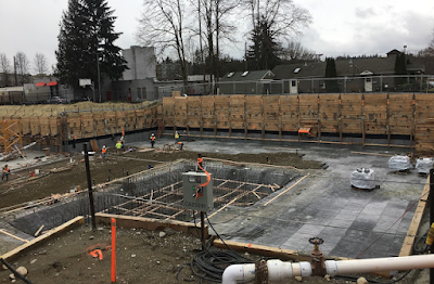
The project involves hiring GeoEngineers consultants to drill a network of 26 monitoring wells in our critical, shallow aquifer recharge area to:

  • track the movement of groundwater
  • track contaminant plumes
  • monitor clean-up efforts
  • evaluate the effectiveness of the hazardous materials management processes
  • enable the City to make better policy decision regarding pollution prevention and groundwater protection.

The mission of this project is a wake-up call! Our underground drinking water supply is extremely fragile and vulnerable to ongoing contamination. In my final Redmond Reporter Citizen Watch column I brought attention to the vulnerability of our well water and the importance of the Cascade Water Alliance and conservation. Fortunately, Councilman John Marchione sits of the Cascade Water Alliance Board so the City has regional voice in planning our water supply for future generations. While interviewing Councilman Jim Robinson for Mayor, Jim told me unequivocally, nothing was wrong with our aquifer. I asked him again. Yes, no problem. ....hmmm....does citizen awareness and openness fit in someplace here?

My Citizen Watch water supply article and other columns I wrote for the community were well received, but the Administration didn't like my shedding light into their corners of government. So, the Administration's community- initiative-public-relations manager issued Advisory action to remove my column. (Since then Redmond Reporter "Letters to the Editor" have been reduced to a trickle -- and this, during a Mayoral election!

NOTE, an aquifer atrocity: A couple of years ago, I and a neighbor, Richard Morris, discovered septic and grease contaminants on Evans Creek bank in SE industrial Redmond. A year later we blew the whistle on a business that required 11 *regulatory agencies to "swoop down" and enforce emergency hazardous waste controls. It was ugly.

The Administration's PR staff (of 8) insisted that all groundwater monitoring controls were in place prior to our discovery of this natural resource atrocity. No doubt our "citizen watch" waved enough red flags to move the City forward in their July 17 update of our Wellhead Protection Program.

After the July 17 Council meeting, Mayor Ives told me my Reporter water supply column was "very good". She had only one concern and that was my urging citizens to ask city officials for a water conservation program. It was my opinion we needed a bonafide program. So far, all I've found in our water conservation program are: free Cascade Water shower heads, RCTV reader board plugs, and FOCUS ad. After my column, the city placed an ad and write-up in FOCUS , ramped up RCTV plugs and the Reporter posted several PSA's. Staff now tells me a new, quantitative water conservation program will be reviewed by Council soon. You'll hear about it here.

** Five shallow wells located east of the Sammamish River supply Redmond with 3.5 to 5 million gallons of water/day or about 40% of Redmond's drinking water. According to the City report of 10/2/07 C.3 "these five wells...are highly susceptible to contamination..."

* regulatory agencies at SE Redmond hazardous waste site were: - EPA, DNR county/city, County Health Dept.,Puget Sound Clean Air, Fire Marshal, Code Enforcement, Wellhead Protection Officer, Department of Ecology.

Saturday, February 9, 2008

High stormwater utility rates under review by council

Two weeks ago past councilman Richard Grubb spoke to council during an "Items from the Audiance talk" about the high costs of stormwater management in Redmond. He was concerned that stormwater fees have increased from $3.00/month in 1988 to $16.56 today.

Granted, stormwater treatment helps to remove sediments and pollutants from run-off before it gets into Bear creek and the Sammamish River. In addition, the city uses stormwater fees & grants to pay for stream and wetland restoration projects for new developments and along Bear & Evans Creek and the Sammamish River. Expensive retention ponds have recently be intalled along the Evans Creek industrial basin. In additon, I think fees have been applied to permit approvals and preservation of Keller Farm wetlands. Keller Farm wetlands are vital to aquifer recharge. Our aquifer supplies 40% of our drinking water. Meandering our waterways to control floods and preserve fish habitat is also funded through stormwater fees & grants.
It is clear, the city really does care about flood mitigation, safety of our drinking water, protection of endangered salmon, and the "swimmability" of Lake Sammamish and the slough. But, as Councilman Hank Margeson stated at the last council meeting -- a 452% stormwater rate increase over 20 years is something to look at. Mr. Margeson is Chair of the Planning and Public Works Committee. It meets the 2nd Thursday of the month at 4:30 pm in the room off of city hall chambers. Hank's committee has responsibility for looking at stormwater treatment issues.

Besides protections of our natural resources and environment stormwater fees will be used to help pay for the new $40 million Regional Treatment facility planned for the Downtown. In 2007 our residential stormwater rate increased by $6.58 to $16.56/single family home just to pay for the Regional facility. Did you notice this on your utility bill last year? According to Mr. Spangler in a 7/25/07 King County meeting, stormwater fees are about 2x those of Seattle.

The city's rational for this 40% increase is "everyone benefits" from the regional stormwater system since about 90% of all treated residential stormwater eventially drains into the Sammamish River. Councilman Pat Vache had concerns about maintenence of private facilities . Maintenance of commercial facilities is "code enforced" and paid by rate fees, according to J. Roetemyer, stormwater engineer. Public Works Director Campbell wasn't clear about maintenance by Homeowners Associations' facilities being "code enforced".

According to Mr. Jon Spangler, city Stormwater Manager, the complete facility will be built by 2011 -12 and have the capacity to ultimately treat 500 acres of future downtown development. Presently, 32.5 acres are developed and will be serviced regionally.

Drivers be aware - a major regional trunk-line on Redmond Way will be built by 2009. You can find the regional stormwater facility MAP "here".

I wrote a story on this in 8/30/07. You can find it on this blog's search engine by searching "spangler regional".

Friday, November 9, 2007

3/10/07 - How safe is our drinking water?


This story was broadly read by the Ives administration after it was published. Shortly after it's publication the City hired a geologist to manage the Wellhead Protection Program; A City FOCUS magazine Public Relations campaign was launched. 1/16/2006

Did you know that almost 40% of our drinking water lies up to 5-20 feet below the surface of the ground? Everyone east of the Sammamish River drinks from our underground "well" water. It's stored in an a large, natural "aquifer" -- formed by an ancient glacial river 10,000 years ago.
The city is doing a pretty good job keeping our ground well water clean but some concerns remain outstanding, as follows:

The city owns and operates 5 wells - 2 near Anderson Park, 1 near Target & Home Depot, 1 at City Hall, and the last one along Avondale Rd. These wells have "wellhead protection zones" classified Zone 1--4 with 1 being most protected.

Multiple housing developments on top of these well protection zones could threaten our water quantity & quality over time.

>>Perrigo Heights - Camwest just proposed building 24 houses on their parcel near Hartman Park. Perrigo Heights sits on a Zone 2 Protection Zone for the Avondale well.
>>Shaunessey Heights - next to Redmond Elementary is proposed for 62 homes. The project will sit on top of a Zone 1 & Zone 2 well protection zone for the Anderson Park well.
>>Avondale Crest - 9 houses were recently approved; the project sits on a Zone 2/1 well protection zone for the Avondale well. Treated stormwater drains into Bear Creek.
>>Tyler Creek - 92 houses are under construction and this project sits on top of a Zone 2 well protection zone for the Avondale well. Treated stormwater drains into Bear Creek.
>>City Hall - was built on a Zone 1 well protection zone adjacent to the city hall well!
>>Mosaic Meadows - is constructing 13 houses on top of a Zone 2 well protection zone for the Avondale well. Stormwater drains into Bear Creek.
>>Redmond Ridge - Zone 2 Wellhead Protection for Avondale well.
>>"Union Hill Industrial" - Zone 1 Wellhead Protection for Avondale well. - recently improved with 2 water treatment detention ponds. Hazardous waste site was discovered by the City and Department of Ecology last year. Untreated stormwater drains into Evan Creek (at this time).
an on....

All these developments meet minimum city construction standards. However, significant impervious surfaces increase with each development. Impervious surfaces reduce the amount of filtrated surface water available to recharge our aquifers with clean water.

Detention ponds are now being replaced by "wet vaults" for stormwater run-off treatment. Wet vaults do NOT remove all the phosphates, nitrates, and heavy metals that run-off of roofs and lawns. Some of these toxic chemicals eventually may soak into our aquifer and wells.

At Perrigo Heights plat a wet vault will be installed next to Perrigo Creek. Toxic chemicals will spill directly into Perrigo Creek and soak into the Hartman Wetlands. The wetlands will eutrify from a mitigated water supply and stormwater toxins.

Each development by itself probably won't have a significant impact to our well water quality. However, as development continues & aggregates our quality & quantity of potable (drinking)water is likely to decline.

60% of our potable water is piped in from the Tolt Reservoir. It costs more than well water.

The Cascade Water Alliance has secured a $55M bond to supply eastern King County water needs. (350,000 are expected to move into King County withing 20 years.) Drinking water will be piped in from the White River (fed by Emmons Glacier on Mt. Ranier) and Cedar River near Tacoma and stored in Lake Tapps. The Mayor of Kirkland first told me of this alliance. He said it was really a big deal. Council member John Marchione attends the Cascade Water Alliance meetings as a Board member for Redmond. The mayor of Bellevue is Chair. Mr. Marchione addresses Redmond's role in the alliance on his campaign webpage. The White River - Lake Tapps pipe in 20 years out.

CASCADE WATER ALLIANCE WEBSITE: www.cascadewater.org/
CITY WELLHEAD PROTECTION MAIN PAGE : www.redmond.gov/groundwater.

Tuesday, October 27, 2015

LETTER: Protecting Redmond's Streams and Groundwater Supply

PROTECTING REDMOND'S STREAMS AND GROUNDWATER SUPPLY

Over the years, I have tried to participate in Redmond's planning and development

process by commenting on projects, especially those that affect the environment.  I have

been concerned about water quality issues that affect our local streams and our

underground aquifer.  The city of Redmond has 5 wells that have a 1.8 BILLION gallon

annual water right. Two wells are located at Anderson Park. One is near Redmond City

Hall. Another is along Avondale Road and the most productive, Well No. 5, is on the

corner between Target and Home Depot.

In 2003, I participated in the writing and adoption of the Wellhead Protection

Ordinance that was meant to keep our drinking water supply clean and safe from

contamination. I attended meetings, made comments on the proposed ordinance and

testified at the public hearing. The Wellhead Protection Ordinance prohibited the storage

of hazardous material and fluids near wells.

I was shocked in 2009 when I read that Costco would be building a warehouse on

the old Redmond Delta gravel pit along 188th Avenue NE south of Union Hill Road and

that it would have a HUGE gas station.  READ MORE >>

Tuesday, October 18, 2022

UPDATED: The Sky's the Limit for Redmond Town Center Building Heights

This sign announces and invites the public to attend and comment at the WEDNESDAY. November, 2nd 7:00 p.m. Hearing about Redmond Town Center building heights. It is installed by the Applicant (Owner) Courtesy of City of Redmond  (click picture to enlarge)

 ATTENTION PUBLIC:  

The City of Redmond Planning Commission will hold a Public Hearing at Redmond City Hall Council Chambers, 15670 NE 85th Street, Redmond, Washington on WEDNESDAY November 2, 2022 at 7 p.m. 

**SUBJECT: Zoning Code Amendment  to provide incentives for additional height in exchange for public benefits, along with minor clarifications to Zone design standards.  


Your comments are encouraged!
  •  Public comment can be made in-person at City Hall, Monday, November 2nd, 7 p.m.
  •  Public Comment can be made by phone during the meeting by providing a name and phone number to PlanningCommission@redmond.gov now or no later than November 2nd, 5 p.m. 
  • Written public comments should be submitted prior to the hearing by email to PlanningCommission@redmond.gov no later than 5 p.m. on the hearing date. 
  • Comments are encouraged and should be sent by email or mail to the planningcommission@redmond.gov.
  • or to: Planning Commission, MS:  P.O. Box 97010, Redmond, Washington, 98073. 

###

A  RESIDENT'S COMMENT TO THE PLANNING COMMISSION: 

What are "the benefits" residents will receive by agreeing to additional building height?  And, how high can the Applicant (Owner) build?  I've heard the Planning Commission and high-level staff are seriously considering 30-story buildings in Overlake Urban Center. They don't have an aquifer to worry about up there.  I've learned the Owner is very concerned about the aquifer interfering with his ability to build subterranean parking. So what are the benefits residents could receive if we give the owner one, two or three stories for above grade parking?  We should  be prepared for a maximum of 12-stories if not an additional 1-2 stories. Growth wins.  

Generous affordable housing is a mustThree and four room apartments for families, please. Other benefits:  8-10 foot pedestrian lit sidewalks with landscaping on either side, leading to plazas and alleys, children's play areas, a park for small dogs, food truck facilitation, outdoor art, interactive water fountains, covered retail and open space for community performances. Adequate street lighting. The scope and massing of two 12-foot and up buildings must be balanced and fit well.  Set-backs similar to Kirkland buildings.  Limit shading.  Wide mobility corridors connecting to Marymoor Village. A stop light at the SR520 Bear Creek Gateway.  Significant and creative landscape, trellised with green walls and green rooftop patio amenities.  Common areas within the buildings have cultural artwork. Walking tours to Lower Bear Creek look-outs. 10-foot plus street trees are necessary. A satellite "Safety Station" with police and mental health specialists overseeing the light rail station and e-scooters.  It's important the Redmond Town Center redevelopment be in character and compatible with the Legacy Nelson Village and the historic district. This could require 1-2 open houses.  If it's decided Nelson or RTC will be eclectic or have some other theme, then the Director of Planning should hold fast to growth unlike at Marymoor Village.  I have no problem with 12 stories if the Applicant provides most of these benefits, whistles and bells.  I don't think they should benefit from any more than two above surface parking levels.  Archer Hotel didn't benefit.  
 
FOR MORE INFORMATION about the proposed Redmond Town Center Code Amendment, Visit  redmond.gov/1860/Redmond-Town-Center. Write to the Planning Commissioners  if you have any serious comments and  questions, or would like to be a Party-of-Record on this proposal, please contact Glenn Coil, Senior Planner, 425-556-2742, gcoil@redmond.gov. A copy of the proposal is available at redmond.gov/Planning-Commission. If you are hearing or visually impaired, please notify Planning Department staff at 425-556-2441 one week in advance of the hearing to arrange for assistance.   

The City is not transparent about the "starting story" and maximum building height.  You have to dig into RZC 21.10.050  "Town Center Regulations and Incentive Standards"  to find the minimum and maximums. 

ACTION: Planning Commission gives their recommendation to Council on the proposed amendment to the Redmond Zoning Code.  Email:  PlanningCommission@redmond.gov.

Updated by Bob Yoder, 10/18/2022

Wednesday, May 20, 2009

Department of Natural Resources uses digital photography to map impervious surfaces for more accurate stormwater billing.

Stormwater treatment infiltration pond next to Evans Creek. Infiltration systems on sensitive Evans Creek properties will be more closely monitored by the City.
UPDATED, 5/21. Opinion: The council voted (7-0) last night to modify stormwater billing to improve billing accuracy. New digital aerial mapping technology allows stormwater engineers to more accurately identify all impervious surfaces (roads, parking, structures) that contribute to dirty stormwater run-off. According staff, an "opt-out" condition only applies to the city-center (downtown) sub-basin, and is only applicable to properties within that sub-basin that are adjacent to the Sammamish River. No change in treatment requirements will apply from this ordinance.
The SW industrial businesses (R.I.C.E.) earlier had lobbied for "infiltration" and against regional treatment improvements. Staff is working with RICE to develop an assessment for existing infiltration systems, and to develop a process and timeline to modify existing systems (if necessary) to reduce risk to the aquifer. The City is building a SW Regional Treatment Plant to treat dirty stormwater more comprehensively and economically along the industrial district of Evans Creek and SW Redmond. Councilmembers Hank Myers and Pat Vache' lended their support to the R.I.C.E. industries during negotiations.
The Administration made some concessions to pass the modification. With staff approval, industries and landowners living adjacent the river would be allowed to "opt out" from hooking into the new Downtown Regional Stormwater Facility. To qualify for reduced rates, a professional engineer would have to make sizing and cost estimates for properties building a private water treatment facility. Department of Ecology water quality standards must still be met. A business could "opt out" for lower rates if their plan was approved by the Staff. Another concession, driven by Myers, was to allow businesses to appeal their bill by October, 2009. Landowners who "opt out" will be reimbursed for the value of their land lost to an on-site facility. Finally, staff had requested that "gravel" count as an impervious surface. The Administration and council decided not to include gravel as impervious, but to study and decide on the issue by December, 2010.

The new digital photography mapping techniques to identify parcels with impervious surfaces is more accurate than on site visits. 78 letters have been mailed to property owners with NEW stormwater bills. Also, the unit measurement of impervious has been "truncated" which will bring higher revenues to the city. In addition, billing by parcel, rather than property owner will add to revenues. Credits will be given for "rain harvesting".

Public Works Director Bill Campbell and Stormwater Manager Jon Spangler, have been progressive and innovative in meeting city needs for cleaner water, all the while, dancing the political jig for council and property owners. Councilmember Hank Margeson concluded the billing modification was really all about cleaner water for our streams (and aquifer zones). Margeson Chairs the Planning & Public Works Committee.
Link to the Modified Stormwater billing ordinance

draft

Friday, January 12, 2024

UPDATED, 2/21/2024 On The Proposed New Redmond Town Center

REDMOND TOWN CENTER REDEVELOPMENT 

Hines will host two neighborhood meetings over the next 12 months. The first meeting will be SOON, in March 6th of 2024 at RTC campus office.  Contact mayor@redmond.gov for times. 

The center's Master Plan review by Council is now underway.  Notably, in addition to the 12-story buildings, three 7-story mixed used residential building are planed.  

 Protecting Redmond’s Aquifer: we’ve positioned all parking above ground to avoid any impact to the aquifer and reduce the carbon impact during construction.

Affordable Housing: At full development, Redmond Town Center will feature up to 200 units of transit-oriented, affordable housing – 2x the minimum contained in the inclusionary zoning ordinance, at 60% of  "Average Median Income."

74th Street: Streetscape improvements on 74th include a transition to a pedestrian-first, engaging open space to enliven the center of the retail core.

Ground Floor Retail: The design includes a net increase of 15,000 – 35,000 square feet of ground floor, pedestrian generating and retail uses, with a portion of that reserved for local, smaller shop retail uses.

Pedestrian and Intersection Improvements: Street and intersection improvements at 166th, 164th, and 76th streets will provide a much more engaging, pedestrian oriented ground plane experience.

Green Roofs: Vegetated green roofs will be included in non-mechanical areas of new building construction to help reduce the urban heat island and help manage stormwater run-off.

Schedule Updates & Opportunities for Feedback:

Neighborhood Meetings:

Hines will host two neighborhood meetings over the next 12 months. The first meeting will be SOON, in March 6th of 2024 at RTC campus office.  Contact info@redmond.gov for times. with another coming in late summer - ~August of 2024. Further details to come here.

Thank you again for participating and sharing your input and questions. We’ll follow up with more updates soon. In the meantime, please visit our Feedback section to respond to our new questions!

-- Hines, 1/12/2024

To find additional blog posts on Redmond Town Center click the "RTC" label. These stories were found at the blog search button. Here are some posts on downtown and the downtown buildings.